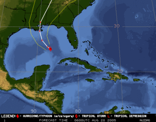
Hurricane Katrina reached Category 4 status early Sunday morning, according to the Public Advisory of the National Weather Service.
If it stays on a westerly path toward a Louisiana landfall -- still no sure thing as the divergent models, above, show -- tropical force winds will affect the entire Pensacola area and a storm surge of 5 feet can be expected on Pensacola Beach, according to the early home delivery edition of Sundays' Penacola News Journal:
"Even if the unpredictable Category 3 hurricane, expected to reach land Monday possibly as a Category 4 storm, keeps to its projected path, dangerous swells and beach erosion threaten the entire Gulf Coast.As of 1 a.m. Sunday, the probability of Katrina's eye passing within 65 nautical miles of Pensacola within the next three days had risen again to 18%. By comparison, Mobile has a 20% chance and New Orleans 25%.
* * *
The National Weather Service issued a hurricane warning from Intercoastal City, La., to the Florida-Alabama state line. A hurricane watch and a tropical storm warning extended from the state line east to Destin.
"There's some very warm water ahead of Katrina," said state meteorologist Ben Nelson on Saturday night. "We could see continued strengthening. Even beyond Category 4 is possible."
At that intensity, storm surge could be dangerous far to the east of landfall. Tropical storm-force winds Saturday night extended out 150 miles from Katrina's eye, the National Hurricane Center reported.
The storm surge in the Gulf-- predicted at about 5 feet for Pensacola beaches -- could stretch hundreds of miles east and west of Katrina's eye. Because of that, and the uncertain direction of the slow-moving storm, Florida emergency officials urged Gulf Coast residents to continue disaster preparation."


No comments:
Post a Comment