Showing posts with label Gustav. Show all posts

Tuesday, September 02, 2008

Backlash - Face Forward

The Pensacola area is getting a little rain this morning from a trailing band of Gustav -- now downgraded to a Tropical Storm. It's almost more moisture than we saw yesterday. At 7 am, the National Weather Service also issued a tornado warning.
AT 6:55 AM CDT...NATIONAL WEATHER SERVICE DOPPLER RADAR INDICATED A SEVERE THUNDERSTORM CAPABLE OF PRODUCING A TORNADO 4 MILES SOUTHEAST OF GULF BREEZE...OR ABOUT 8 MILES SOUTH OF PENSACOLA... MOVING NORTHWEST AT 20 MPH.
Local weather should look up soon, but then we'll have to start watching Hanna, Ike, and Tropical Depression No. 10.

Monday, September 01, 2008

Gustav Warnings for Pensacola Discontinued

NHC:
AT 10 AM CDT...1500 UTC...THE TROPICAL STORM WARNING IS DISCONTINUED EAST OF THE ALABAMA-FLORIDA BORDER. A TROPICAL STORM WARNING CONTINUES FROM THE MISSISSIPPI-ALABAMA BORDER TO THE FLORIDA-ALABAMA BORDER.
There are still visible in satellite images one or maybe two outer bands of Hurricane Gustav that might freshen the air or dump a little more rain in the Pensacola area, but for all practical purposes the potential emergency here is over. It continues for New Orleans, the Delta, and eastern Texas.

Pensacola Beach Cam

Aloha Surf has the most reliable beach cam on Pensacola Beach.

Navarre Beach Weathers Gustav

Live cam of Navarre Beach, 8 miles east of Pensacola Beach. This view is looking south, across the 1/2-mile wide Santa Rosa Sound.

Gustav Live from New Orleans

New Orleans live cams.

Florida Dodging Gustav's Fury


Good news!

"The hurricane warning east of the Mississippi-Alabama border to the Alabama-Florida border has been changed to a tropical storm warning."
At 4 am CDT, NHC reports the center of Gustav is about 100 miles south of New Orleans. It is a Category 3 hurricane with maximum sustained winds of 115 mph and higher gusts. The center of the storm is moving northwest at a speed of 16 mph.

NHC at 4 am has more, most of it good for Northwest Florida:
No significant change in strength is likely before landfall... with weakening expected to begin after Gustav moves inland later today.

Hurricane force winds extend outward up to 70 miles... from the center... and tropical storm force winds extend outward up to 230 miles... .
* * *
An extremely dangerous storm surge of 10 to 14 feet above normal tidal levels is expected near and to the east of where the center of Gustav crosses the coast.

Gustav is expected to produce total rainfall accumulations of 6 to 12 inches over portions of Louisiana... Southern and Western Mississippi... Arkansas and Northeastern Texas... with isolated maximum amounts of up to 20 inches possible through Thursday.
Locally, winds are very gusty and hard rains fall as each outer storm band passes overhead. Total overnight accumulations are less than an inch at this time.

Gustav Monday Morning


Current conditions just before dawn are windy, warm and wet. Unfortunately, the Pensacola Beach Elementary School weather station is, as usual, not functioning.

The nearest substitute we can find is the Weather Underground personal weather station known as "Sawgrass at Tiger Point" in Gulf Breeze, a peninsula location across Santa Rosa Sound from the Portofino condos. It is directly exposed to weather from the the island less than a mile away. (Click image on left for close up.)

To check out other personal weather stations in the western Panhandle area, go to...
WEAR-TV
(Pensacola Beach Elementary School - disabled)
Weather Underground
(From NAS to Navarre)
... then then scroll down the page to select a specific personal weather station.

Sunday, August 31, 2008

Gustav Sunday Afternoon

UPDATED BELOW - I, II, and III

The 
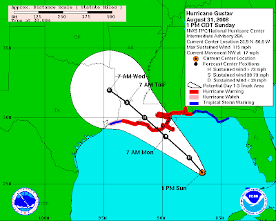
early Sunday afternoon NHC advisory remains pretty much the same: Gustav is a Cat 3 but may re-intensify to a Cat-4 within the next 24 hours. The projected path bringing this major hurricane ashore just west of New Orleans remains roughly the same.

Pensacola and the rest of the Florida Panhandle to Tallahassee remain under a Tropical Storm Watch Warning -- not a hurricane watch Warning.

Rumors to the contrary notwithstanding, Escambia County Emergency Management officials have not -- repeat, not -- ordered any evacuations as yet. However, swimming in the Gulf is now prohibited; and, alas, "the bathtub races scheduled for 2 pm today" have been postponed.

Local conditions: Overcast skies, warm, dry, muggy, with light winds and occasional gusts to 15 mph.

UPDATE I
3 pm

Sudden pick-up in wind, now stiff and gusting to 35 mph. Bands of driving rain have arrived. Typically for a tropical storm, the rain is cold, almost horizontal, and comes in needle-like drops.

UPDATE II
6:30 pm

No more rain bands, as of now, since mid-afternoon, but meteorologist Derek Ortt over at the PNJ's Storm Watch blog says:
The main rain shield is not too far from the coastline. This may move onshore during the evening hours. If this does move over the area, sustained tropical storm force winds with higher gusts will begin to affect the area.
Local conditions at 6:45 pm: Overcast, muggy, winds stiffer and a bit more blowy, but dry since 3 pm. Six feet waves seen off the beach.

UPDATE III
7:00 pm

"You Can't Probably Shouldn't Go Home Again"

Mercenaries are being recruited by Blackwater Worldwide "to potentially deploy to provide security in the possible aftermath of Hurricane Gustav. This is the first time Blackwater has mobilized under its controversial Homeland Security contracts."

Gustav Landfall Expected Monday

NHC, 7 am CDT: Gustav lost a little muscle mass overnight and at this early hour is now back to Category Three status. It is expected to regain strength as the day progresses and "Gustav could regain Category Four strength later today or tonight."

The storm is moving across the central Gulf of Mexico in a northwesterly direction at about 16 mph. First landfall on the Gulf coast looks to be some time Monday.
GUSTAV IS A LARGE TROPICAL CYCLONE. HURRICANE FORCE WINDS EXTEND OUTWARD UP TO 50 MILES... 85 KM... FROM THE CENTER... AND TROPICAL STORM FORCE WINDS EXTEND OUTWARD UP TO 200 MILES.
* * *
AN EXTREMELY DANGEROUS STORM SURGE OF 18 TO 25 FEET ABOVE NORMAL TIDAL LEVELS IS EXPECTED NEAR AND TO THE EAST OF WHERE THE CENTER OF GUSTAV CROSSES THE NORTHERN GULF COAST.
For a live view of the bridge over Mobile Bay, CLICK HERE.

Saturday, August 30, 2008

Pensacola Area Radar

Cuba TV Storm Coverage - Live

Video streaming by Ustream

Pensacola Official Gustav Storm Watch


NHC, 4 pm CDT:
A HURRICANE WATCH IS ISSUED FOR THE NORTHERN GULF COAST FROM EAST OF HIGH ISLAND TEXAS EASTWARD TO THE ALABAMA-FLORIDA BORDER...INCLUDING THE CITY OF NEW ORLEANS AND LAKE PONTCHARTRAIN. A HURRICANE WATCH MEANS THAT HURRICANE CONDITIONS ARE POSSIBLE WITHIN THE WATCH AREA...GENERALLY WITHIN 36 HOURS.
The Alabama-Florida border is less than 20 miles east of downtown Pensacola.
Also:
A TROPICAL STORM WATCH IS ISSUED ALONG THE PANHANDLE COAST OF FLORIDA FROM EAST OF THE ALABAMA-FLORIDA BORDER EASTWARD TO THE OCHLOCKONEE RIVER. A TROPICAL STORM WATCH MEANS THAT TROPICAL STORM CONDITIONS ARE POSSIBLE WITHIN THE WATCH AREA...GENERALLY WITHIN 36 HOURS.
The Ochlockonee River watch area encompasses all of North Florida to the Cedar Key-Big Bend area.

"Lawkat" -- a Mobile lawyer, as we recall -- over at Hurricane City's Message Board is asking locals to "check in" and share their anxieties, questions, and concerns.

Louisiana Evacuates

Mandatory evacuation has been ordered for St. Bernard, Plaquemines, St. Charles and lower Jefferson parishes. AFP global wire service has the latest details:
Desperate to avoid a repeat of the Katrina catastrophe in 2005, New Orleans began mandatory evacuations Saturday as another deadly hurricane, Gustav, bore down on the city.

Bumper-to-bumper traffic clogged roads leading north and east out of New Orleans and shops began running low on fuel and emergency supplies as the dangerous category three hurricane barrelled toward the Gulf of Mexico after leaving up to 85 people dead in Caribbean nations.
* * *
"Obviously people can stay. We are encouraging them to leave," said Craig Taffaro, president of St. Bernard Parish, one of the areas of greater New Orleans to call for mandatory evacuations three years after Hurricane Katrina breached levees protecting the low-lying city, killing some 1,500 people.

"We know this is a very difficult decision. Emotions are very high, but we have to take a practical approach to this," he said.

Coastal parishes in New Orleans began the first mandatory evacuations at noon (1700 GMT). Police were set to enforce a nightly curfew and cordon off areas under evacuation order, so that no one could enter.

Residents were warned that the city would not have emergency shelters, and that gathering areas such as the Superdome and bus terminal -- scenes of chaos and violence after Katrina -- would be closed.
* * *
The overall population of greater New Orleans is estimated at more than one million people, about 80 percent of the pre-Katrina population. Saturday's mandatory evacuation orders affected more than half of New Orleans' seven parishes.

The New Orleans airport said it would shut down Sunday evening, and area hotels advised customers to leave town.

Gustav a Category 4; Same Forecast Path

Gustav is now a Category Four Hurricane with "maximum winds near 145 mph."

NHC 1 pm CDT:
No changes to the forecast track have been made... but the intensity forecast has been adjusted upward through 96 hours. Gustav could intensify some more during the next few hours over water... and one cannot rule out Category Five intensity before crossing Cuba. The forecast now calls for a peak ... Category Five intensity... over the Southern Gulf where ocean heat content will still be high... followed by a very gradual weakening over the Northern Gulf where ocean heat content is less.

Gustav Satellite View

Is there any wonder the computer models agree on Gustav's future path?

Gustav Grows

Gustav grew larger and stronger overnight, today's early morning NHC discussion report says. It is, for now, a Category 3 storm with maximum winds about 115 mph, as measured by the latest Air Force hurricane hunter airplane.

So large and strong has the storm become that even if it encounters some sheer before landfall, as NHC now expects, "Gustav is expected to be a large and dangerous... major hurricane at landfall."

Forecast models, however, have persuaded the NHC to shift the 3-day predicted storm path (above) a little farther west. This would leave the Pensacola Beach area -- for the moment, anyway -- looking like it just might avoid being a central target. Depending on size of the storm and proximity to its center, however, we still might be on the east side of the storm, where water surges can be more marked.

The computer forecast models runs, seen below, are coming into strong agreement, for now. But things could change at any time, so it's no time to relax just yet.

Friday, August 29, 2008

Gustav Regains its Gusto

Gustav is again a hurricane. And, it is still confounding the experts at the National Hurricane Center. All they feel comfortable saying publicly is:
  • "Conditions over the Gulf appear to support a major hurricane;" and
  • "Final landfall remains possible throughout the Northern Gulf Coast."
If you drill down deep enough on the Hurricane City Message boards, you'll run across a plausible but unsourced assertion earlier today that NHC forecasters --
have shifted the course to the east, but not as far as they wanted to. The comment was made that they wanted to avoid the "Windshield Wiper" effect. Expect NHC to move the course further east at the next update.
Repeat: unsourced. We shall see just how far east, if at all, that cone shifts over the next 48 hours....

Gustav Grows, Hanna Confounds

Today's early morning NHC discussion has worrisome news. Gustav is growing in size -- and the steering currents are growing even more complicated.
  • Gustav has grown in size.
  • Upper-level steering currents that have been edging it westward are expected to "weaken" today.
  • After passing Jamaica today, Gustav could strengthen "quickly" to a Category 3 hurricane.
  • Complicated interactions among various upper-level North American wind patterns -- the "mid-level ridge" over Florida, an expected "low"over the Southeast United States, a possible "weakness" in the Bermuda high," and another anticipated "high over the Ohio valley" -- leave the experts scratching their heads over just where along the Gulf Coast Gustav is likely to head after passing Cuba.
  • As a result, the latest computer-generated forecasts show "large changes" and increasing disagreement about the storm's projected path.
The one near certainty, blares the Hurricane Center in the usual capital letters:
"GUSTAV IS EXPECTED TO BE A LARGE POWERFUL HURRICANE AS IT APPROACHES THE NORTHERN GULF COAST."
As for T.S. Hanna, interactions among some of the same upper-level wind patterns leads the hurricane experts to conclude, for now, that Hanna will continue heading northwest for a time, then take a "rare, but not unique" southwesterly track while it fluctuates in strength for a couple of days.
Most of the global models are carving a large trough over the Central Atlantic and developing a large ridge over the eastern United states. This pattern should force Hanna on a slow Southwesterly track beyond three days... but at the same time the upper-level winds should weaken the cyclone.
Speaking of "rare but not unique," NHC forecaster Avila finds the picture so complicated he openly confesses, "I prefer to wait for more model runs" before making a forecast.

When even the savants at the National Hurricane Center decline to predict a storm path, you know things are truly up in the air.

Thursday, August 28, 2008

Gustav Update

NHC, 5pm:
The chances of hurricane-force winds within the next five days are essentially the same at each individual location from the Florida Panhandle coast westward through the entire coastline of Louisiana.