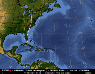
"It was forecast to hit hurricane-weary New Orleans as a Category 3. Then it aimed toward Pensacola. Then Tampa. On Monday, it moved over eastern Cuba and set its sights on South Florida, where it is expected to make landfall late tonight or early Wednesday."-- St. Petersburg Times, Aug. 29, 2006
The governor of Florida has declared a state of emergency... state and federal courts ... schools and colleges... sporting events... a space shuttle launch... road construction... scores of professional events ... airports, cruise ship routes, scheduled hospital elective surgeries... early voting and poll watcher training for the state primary election... and meetings up and down the Florida peninsula were being canceled Monday, in anticipation of T.S. Ernesto. But politicians carry on.
The storm left the mountainous eastern region very early today and is now in the Gulf, in a substantially weakened and disorganized condition. At 5 am the National Hurricane Center was saying:
NOW THAT ERNESTO HAS MOVED BACK OVER WATER...AT LEAST SOME STEADY INTENSIFICATION IS EXPECTED. A SMALL BUT POTENT UPPER-LEVEL LOW SITUATED ABOUT 120 NMI NORTHWEST OF ERNESTO IS ENHANCING THUNDERSTORM DEVELOPMENT...BUT IS ALSO CREATING SOME SOUTHERLY SHEAR AND PUNCHING DRY AIR INTO THE SOUTHERN SEMICIRCLE. HOWEVER... THE HINDERING EFFECTS OF THAT SYSTEM ARE FORECAST BY ALL THE MODELS TO DIMINISH WITHIN THE NEXT 12 HOURS AS ERNESTO IS PASSING OVER THE WARM GULFSTREAM.Privately, many are predicting the storm will amount to not much more than a very heavy rain storm, but no one wants to say so. And that's good.
IN 18 HOURS OR SO...THE VERTICAL WIND SHEAR ACROSS ERNESTO IS FORECAST TO BE NEAR ZERO...SO THERE IS STILL SOME CHANCE THAT THE CYCLONE COULD BECOME A HURRICANE BEFORE REACHING FLORIDA. ALSO...AFTER ERNESTO RE-EMERGES OVER THE ATLANTIC...IT IS POSSIBLE THAT IT COULD RE-STRENGTHEN TO NEAR HURRICANE INTENSITY BEFORE MAKING A SECOND U.S. LANDFALL NEAR THE SOUTH CAROLINA-NORTH CAROLINA COASTS.
We've seen this phenomenon before after Hurricane Opal devastated northwest Florida in 1995. Everyone goes on alert for the next bad storm. We're told to expect the worst. Government officials urge residents to evacuate early. Everything shuts down. Residents skedaddle. Tourists flee -- or cancel plans to arrive.
And then there's a big let-down when the worst doesn't materialize. Millions in business revenue are said to have been lost. Residents grumble they were inconvenienced. Schools complain they have to make up days.
Again it happens, and maybe again. Eventually, don'cha know, in a year or two people tend to slip back into a sense of complacency.... we relax... take our sweet time watching and waiting .... dismiss some new distant threat as just another false alarm.
And then a new version of Ivan or Katrina wipes everything out. And it starts all over again.
As one blogger puts it today:
[O]ur situation is precarious, wherever we live— on the fault line, in tornado alley, at the base of a volcano. We all could be the next New Orleans with little warning.On this anniversary of Hurricane Katrina, the responsible reaction of Floridians to Ernesto is a reminder that we can't fool Mother Nature -- but she sure can fool us.


1 comment:
Good post. Those who don't know hurricane history are bound to repeat it.
Post a Comment