Friday, August 26, 2005

Gas Lines Forming

Polyana (don't you just love that name at times like these?) da Costa and Carlton Proctor of the Pensacola News Journal report on line at mid-day that "Panhandle area residents have started to line up at gas stations to fill up their tanks in preparation for Hurricane Katrina."

There's more:
Haruka Umeda, a worker at Raceway, a Gulf Breeze station, said people were buying an average of $100 of gasoline for generators and vehicles. She received a delivery this morning but is not expecting it to last beyond tonight.

Larry Adkinson, owner of a station in Cervantes said traffic has started to pick up at his station as well. He still has 4,000 gallons of gas left, which he expects to last for a couple days.

* * *
"We’re busy, busy, busy," said Stephanie Young, store manager at a Shell station on Mobile Highway. "We ran out last night, but got another truck in about 2 a.m., so we’re in good shape. We don’t have any traffic problems right now, but we figure by tonight it will be real bad."

"We’ve been slammed since 6 a.m.," said Neel Clark, assistant store manager [of a Shell station on Mobile Highway]. ... We’re out of regular gas, but we’ve got plenty of premium."

At the Circle K on Langley Avenue, store clerk Lisa Stacey said they have run out of regular, but have a truck on the way with another shipment.

Unlike the mad rush prior to Hurricane Dennis last month, the good news is that there is plenty of gas product available in the Pensacola area, said Tom Kelly, a spokesman for Radcliff Economy Marine, also know as Mocar.


The daily morning Pensacola News Journal is posting reporters' Hurricane Katrina stories today as they are filed.

Escambia County Declares Emergency

The Escambia County Board of County Commissioners declared a Local State of Emergency today at 10:45 a.m. [CDT] due to the potential of Hurricane Katrina.

Special Advisory: "Kat" To Be A 4

A highly unusual 'special advisory' was issued by the National Hurricane Center at 10:30 a.m. CDT, predicting that Hurricane Katrina will reach Category 4 status in the next two days:
STEADY INTENSIFICATION TO NEAR CATEGORY FOUR STRENGTH BY 72 HOURS APPEARS TO BE IN ORDER GIVEN THE VERY WARM GULF WATERS BENEATH THE HURRICANE AND THE VERTICAL SHEAR FORECAST TO DECREASE TO LESS THAN 10 KT BY 48 HOURS.
Category 4 status means sustained winds of 131-155 mph, extensive roof damage, and likely road wash-outs in low lying areas.

Read the complete list of descriptive symptoms here.

Pensacola A Target Again


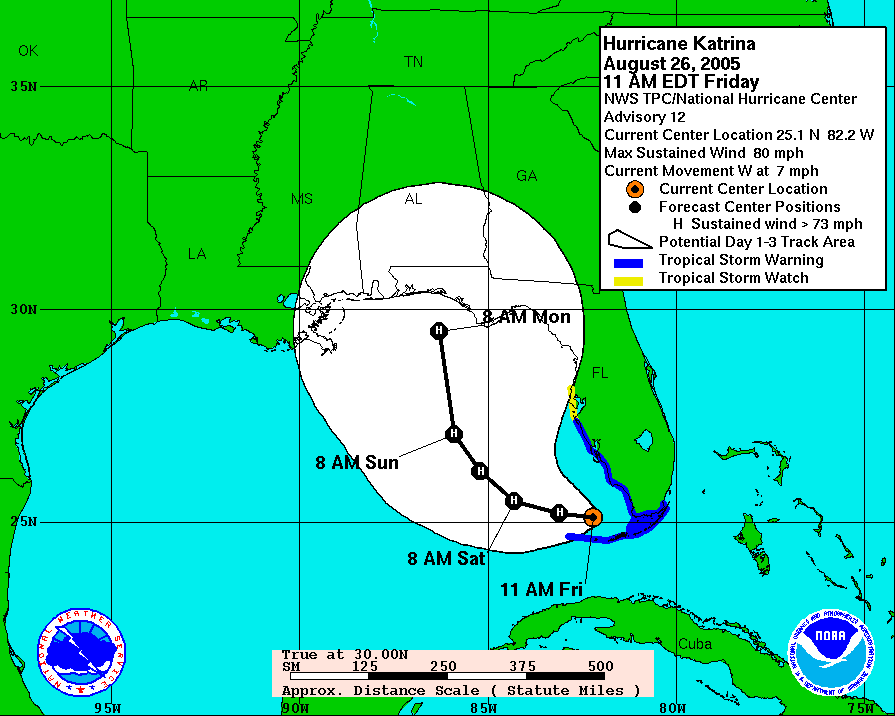
The 11 a.m. EDT update on Hurricane Katrina predicts the storm will soon reach Category 2 status with sustained winds of 96-110 mph. It also confirms the projected path has moved farther west from Apalachicola, once again, putting Pensacola near the bullseye.

Things could change -- and likely will. The NHC erred yesterday in predicting Katrina would slowly march across Broward County (Ft. Lauderdale) in crossing the southern tip of Florida. Instead, she hit farther south in Dade County (North Miami) and progressed fairly rapidly over the Everglades while crossing the Florida peninsula. Instead of losing strength over land, the storm actually gained power.

At 11 a.m. EDT Friday, NHC officially inched its 3-day path projection westward, again. It now targets an area nearer Destin. Unofficially, NHC weather pronosticators are being quoted on radio as predicting Hurricane Katrina will be at least a category 3 storm when it makes landfall.

Locally, everybody one encounters seems instantly aware of the latest weather news and nuanced variations in the forecasts. No one is taking any chances. Vehicles are gassing up, the aisles of hardware stores are filled with shoppers, bottled water is flying off grocery shelves.

As you can see in their eyes, the drill is all too familiar to panhandle residents.

Katrina's Wobbly Projections


Hurricane Katrina lost little of its power after hitting North Miami about 7 p.m. and crossing over the "the relatively moist everglades" Thursday night. The Category 1 hurricane is now in the Gulf of Mexico, heading west-northwest.

Early this morning, an NHC meteorologist told National Public Radio's Morning Edition that current projections are it will strengthen and make a second landfall "anywhere from central Florida to the Florida panhandle."

The worrisome thing for Pensacola residents is that official storm projections now are shifting the projected landfall point more westerly away from yesterday's 5-day target of Apalachicola.

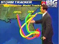
First, experts had it headed for Pensacola. Then, they shifted the projection cone toward the east. As of now, the dynamic archive of storm projection models shows a path turning westerly again.

Thursday, August 25, 2005

Katrina's Personality

Photo courtsey of WKMG-TV Channel 6, Orlando

Every tropical storm, it seems, has its own peculiar personality -- at least as experienced on Pensacola Beach.

Erin (Aug. 1995) was windy but relatively dry. Opal (Oct. 1995) was marked chiefly by a devastating water surge. Danny (July 1997) hung over Mobile forever, so it seemed, and actually emptied the bay of water. Georges (Sept. 1998) brought tons of rain and beach-eroding wave action. And Ivan (Sept. 2004)...well, everyone knows what Ivan was like; the evidence is still all around us.

So, what kind of personality does Katrina have? After speaking with state meteorolgist Ben Nelson, the Treasure Coast newspapers report that "Katrina has a large rain field but a small wind field. Tropical storm-force winds expand 70 miles from the center... ."

Governor Jeb Bush today passed along what he was told to expect for South Florida:
Storm surge is less of a concern for Katrina, which is expected to be a Category 1 storm by the time it reaches land, but rain is the biggest problem in the already soggy state, Bush said.

"This system will bring tremendous rain to the peninsula," he said.
That's south Florida, of course. There's no telling what personality defects Katrina may acquire by the time she hits the Gulf Coast early next week -- or where she'll make landfall. But you can follow her closely at Jim Williams' Hurricane City web site and get all the right (and wrong) guesses on the Hurricane City Message Board.

Forecasting Katrina: Follow the Money


Overnight, the official National Hurricane Center's forecast track for T.S. Katrina slipped slightly eastward. We know this not only from the usual 5-day weather cone map, but also because crude oil futures were "little changed" in overnight trading, according to Bloomberg's wrap-up for the European commodities markets:
Crude oil was little changed after reaching a record $68 a barrel in New York as forecasts indicated Tropical Strom Katrina may veer away from U.S. producing areas in the Gulf of Mexico.

Katrina is expected to enter the Gulf after crossing Florida tomorrow and may make landfall in the state's panhandle in three days, according to the U.S. National Hurricane Center. * * *

"It seems like the storm is trailing away," easing concern about an output halt at oil and gas rigs, said Christopher Bellew, a broker at Bache Financial Ltd. in London.
By "trailing away," broker Bellew obviously means trailing away from the west-central portions of the Gulf where the drilling rigs are.

Pensacola still is not entirely out of danger, by any means. As
Sean Smith reports
in today's PNJ:
While the latest five-day forecast has Katrina making landfall near Apalachicola, 150 miles east of Pensacola, the track is far from a sure thing.

"If you take our forecast errors into consideration, it could hit anywhere from Alabama to the Florida Big Bend," said Hugh Cobb, National Hurricane Center meteorologist.
If you've bet all of your frail mother's dough on rising gas prices, there's more good news to come -- another low pressure area between the Cape Verde Island and the Lesser Antilles. According to the National Hurricane Center:
Although this system remains in an area not favorable for further development... the shear is forecasted to relax over the next day or so... Thus there is a possibility of tropical cyclone.
It looks all good if you're betting on rising oil prices.

Wednesday, August 24, 2005

Be A Witness

If you're sick of television's obsession with tangential tabloid tales while ignoring important world news, watch the "Be A Witness" video ad. It's cogent, convincing, and even funny in a bitter, Jonathan Swift way.

Unfortunately, you can only see it on the Internet. The three major networks and two other media conglomerates have refused to sell ad time to the sponsors. So, send a message to CBS, ABC, NBC, Allbritton Communications, and Gannett Corporation to tell them "Genocide Is News."

The "Model Consensus"


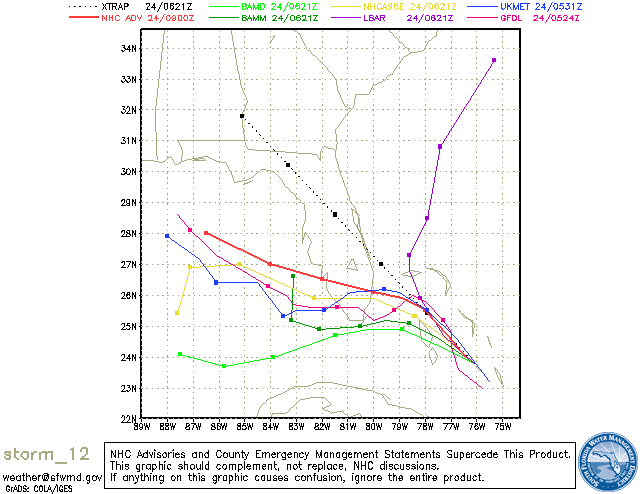
At 5 pm Wednesday, August 24, the National Hurricane Center says its computer models:
"... differ signficantly on where and when Katrina is expected to turn Northward and make a second landfall along the Northeast Gulf Coast. The GFDN is the western-most model and takes the cyclone to New Orleans ...whereas the GFS and Canadian models are the easternmost models and take Katrina Northeastward across the northern Florida peninsula. The office track is near the middle of the guidance envelope and close to the model consensus."
And that consensus?

Sure looks like Pensacola.

Katrina To Be A Gulf Hurricane

65 Knots = 74.9 mph

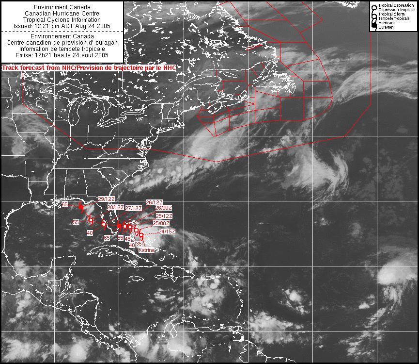
The NHC 11 am EDT forecast for T.S. Katrina calls for it to 'steadily intensify', turn more westerly tomorrow, cross the Florida peninsula, reemerge in the Gulf, and become a hurricane.

The capital-letter shouting is from the National Hurricane Center:
KATRINA... IS EXPECTED TO SLOWLY BUILD EASTWARD...CAUSING THE CYCLONE TO TURN MORE WESTWARD AFTER 24 HOURS AND CROSS THE SOUTHERN FLORIDA PENINSULA. AFTER EMERGING OVER THE EASTERN GULF OF MEXICO IN 72 HOURS...THE WESTERN PORTION OF THE RIDGE IS FORECAST TO WEAKEN AND ALLOW KATRINA TO MOVE NORTHWESTWARD.

* * *

KATRINA IS EXPECTED TO BECOME A HURRICANE PRIOR TO LANDFALL

Andrew Anniversary


August 24, 1992

Tropical Storm Katrina


As feared yesterday morning, a tropical storm has formed near the Bahamas and is expected by the NHC to navigate into the Gulf by this weekend. T.S. Katrina could possibly become a hurricane by Sunday or Monday.

Widely scattered computer model projections early Wednesday show that both the eventual direction and intensity of T.S. Katrina remain uncertain for the time being. However, Pensacola area residents, and particularly barrier island homeowners and businesses, should keep a careful watch on this developing storm.

Slapped in the Face - Again

Slap us once, shame on you. Slap us twice, shame on us.

Florida consumers ought to be feeling a lot like an abused spouse. The serial abuser is the state legislature, this time aided and abetted by Governor Jeb Bush.

Today's PNJ is carrying Paige St. John's latest report about how Florida has shut out the consumer's voice once again when insurance policies are up for discussion. (Free web access to her article will continue for some time at the Ft. Myers News-Press.)

Here's the essence of it:
Consumers don't have a seat on a legislative panel that meets today to take up the problem of helping Floridians get hurricane insurance.

Task force members named this week include some of the loudest voices in Florida for higher premiums, exemptions to wind-resistant building codes, and increased reliance on policyholders to cover insurers' claims after catastrophic storms.

The 12-member Task Force on Long-Term Solutions for Florida's Hurricane Insurance Market includes no consumers.

* * *
The task force was ordered by the Legislature last spring to address issues lingering from the 2004 hurricanes. It is required specifically to look at the thousands of policies major insurers are now turning away, forcing more homeowners into the state-run Citizens Property Insurance.

The legislation requires Gov. Jeb Bush's three appointments to include a voice for "insurance consumers." In that slot, Bush named the president of an insurance-created group that advocates storm shutters and other home-disaster preparation but is silent on controversial matters like rates.


This isn't the first time ordinary consumers have been given the back of the hand by one of Florida's top elected leaders. Last December, Tom Gallagher, the second most powerful Republican official in Florida, appointed a 13-member "Task Force on Policyholder Services and Relations to Citizens Property Insurance." It included everyone but an ordinary consumer.

As with a battered spouse we want to ask, 'Why do these brutes treat consumers like dirt?' But we should be asking, 'How much longer are we going to put up with this abuse?'

Tuesday, August 23, 2005

"Cape Verde" Season

"This is the time of year when people should keep their eye on the forecast in the tropics," according to National Hurricane Center forecaster Hugh Cobb. "We are entering the Cape Verde season."

Graham Brink of the St. Petersburg Times adds:
Late August and early September are historically the most active for tropical storms and hurricanes.

* * *
On average, about 60 waves generate over North Africa each year, according to the National Hurricane Center.

The waves spawn about 60 percent of tropical storms and minor hurricanes that form in the Atlantic Basin - the Atlantic Ocean, Caribbean Sea and Gulf of Mexico. Nearly 85 percent of major hurricanes originate from the waves.
Currently, the National Hurricane Center is keeping one eye on the remnants of former Tropical Depression 10, which may be re-strengthening along the Cuban coast, and the other eye on a strong tropical wave in the far eastern Atlantic.

Monday, August 22, 2005

Tropical Gambling

There's an old poker players' expression. "If you look around the table and you can't tell who the sucker is -- then it's you."

Intrepid investigative reporter Paige St. John nails the Florida Office of Insurance Regulation today for gambling on the weather. The thing of it is, it looks like we're the suckers. The state is gambling with our homeowner's money but it won't tell us about it.
Rather than shut down insurers tottering from last year's hurricanes, Florida regulators are letting them grow with the riskiest policies in the state.

It's a gamble on the weather.

Florida homeowners are on the hook to pay if they lose. There's the promise of a healthier market and, maybe, competition to drive down rates if skies stay blue.
Yeah, right. Lower insurance rates. More like, 'heads you lose, tails they make bigger profits.'

Just last month, we warned of this by asking if Citizens Property Insurance had "depopulated you to a dog?" Now, evidence is surfacing that both state regulators and the state-owned Citizens Property Insurance Corp. have deliberately blinkered themselves against the growing number of Florida property insurance companies that cannot cover losses if there's another hurricane.

St. John explains:
State regulations require property and casualty insurers to have the larger of $5 million capital, or 10 percent of their liabilities. But 2004 storm losses emptied many of those accounts and parent companies and private investors have not put all of it back.

Financial records show at least five companies with thin capital, some under regulatory watch and others with assets inflated by future tax deductions and solvency ratings of "weak" and "marginal."

If companies fail, policyholders recover only losses up to $300,000 through Florida's Insurance Guaranty Association. Homeowners across the state would pay the bill through assessments added to already rising premiums.

* * *
Among those in trouble is Florida's fifth largest insurance holding company, Poe Financial Group. All three of the Tampa-based company's insurance subsidiaries, Atlantic Preferred, Florida Preferred and Southern Family, have ceased allowing their books to be viewed by financial rating companies.
So how can you tell if Florida officials are gambling with your homeowner's insurance? You can't -- thanks to the state legislators you sent to Tallahassee. It's a "state secret."
The Florida Office of Insurance Regulation would not say how many companies fell out of compliance with solvency requirements after the hurricanes, or remain there still. Legislators have made such records confidential, hidden even to policyholders.
In other words, Florida legislators have created a system that even a Biloxi casino would envy. They gamble with your money while protecting what St. John calls "friends and family" insurance companies.

Whose "friends" and "family"? Why, the relatives and buddies of state legislators and insurance industry executives, of course -- as just about any property insurance agent in Florida will tell you.