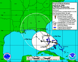
At 5 pm Wednesday, August 24, the National Hurricane Center says its computer models:
"... differ signficantly on where and when Katrina is expected to turn Northward and make a second landfall along the Northeast Gulf Coast. The GFDN is the western-most model and takes the cyclone to New Orleans ...whereas the GFS and Canadian models are the easternmost models and take Katrina Northeastward across the northern Florida peninsula. The office track is near the middle of the guidance envelope and close to the model consensus."And that consensus?
Sure looks like Pensacola.


No comments:
Post a Comment