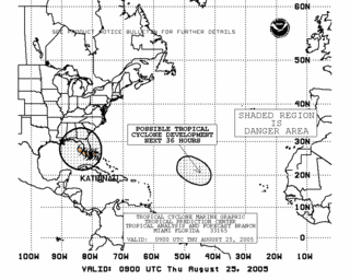
Overnight, the official National Hurricane Center's forecast track for T.S. Katrina slipped slightly eastward. We know this not only from the usual 5-day weather cone map, but also because crude oil futures were "little changed" in overnight trading, according to Bloomberg's wrap-up for the European commodities markets:
Crude oil was little changed after reaching a record $68 a barrel in New York as forecasts indicated Tropical Strom Katrina may veer away from U.S. producing areas in the Gulf of Mexico.By "trailing away," broker Bellew obviously means trailing away from the west-central portions of the Gulf where the drilling rigs are.
Katrina is expected to enter the Gulf after crossing Florida tomorrow and may make landfall in the state's panhandle in three days, according to the U.S. National Hurricane Center. * * *
"It seems like the storm is trailing away," easing concern about an output halt at oil and gas rigs, said Christopher Bellew, a broker at Bache Financial Ltd. in London.
Pensacola still is not entirely out of danger, by any means. As
Sean Smith reports in today's PNJ:
While the latest five-day forecast has Katrina making landfall near Apalachicola, 150 miles east of Pensacola, the track is far from a sure thing.If you've bet all of your frail mother's dough on rising gas prices, there's more good news to come -- another low pressure area between the Cape Verde Island and the Lesser Antilles. According to the National Hurricane Center:
"If you take our forecast errors into consideration, it could hit anywhere from Alabama to the Florida Big Bend," said Hugh Cobb, National Hurricane Center meteorologist.
Although this system remains in an area not favorable for further development... the shear is forecasted to relax over the next day or so... Thus there is a possibility of tropical cyclone.It looks all good if you're betting on rising oil prices.


No comments:
Post a Comment