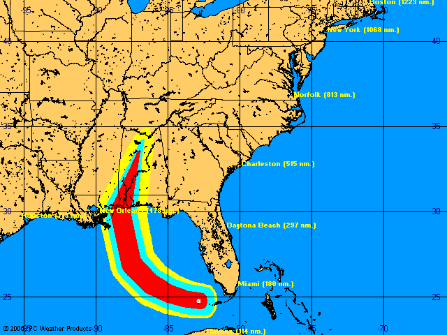
As of the National Hurricane Center's 5 p.m. forecast, Katrina's projected path has shifted to the West once again. Presently, this would pinpoint landfall just west of Mobile, AL -- a smidgen farther than Ivan but in the same close vicinity.
According to the NHC:
AFTER 24 HOURS... THE MODELS ARE IN GENERAL AGREEMENT ON A SHORTWAVE TROUGH CURRENTLY OVER THE NORTHERN AND CENTRAL PLAINS STATES TO GRADUALLY DIG SOUTHEASTWARD TOWARD THE CENTRAL AND WESTERN GULF OF MEXICO...WHICH ALLOWS KATRINA TO MOVE NORTHWARD BY 72 HOURS. AS A RESULT...THE MODELS HAVE SHIFTED SIGNIFICANTLY WESTWARD AND ARE NOW IN BETTER AGREEMENT.Although there remains substantial uncertainty about the ultimate point of landfall, the NHC seems to be quite certain about the storm's strength:
THIS HAS RESULTED IN THE OFFICIAL FORECAST TRACK BEING SHIFTED ABOUT 150 NMI WEST OF THE PREVIOUS TRACK...ON THE EAST SIDE OF THE GUIDANCE ENVELOPE. HOWEVER... PROJECTED LANDFALL IS STILL ABOUT 72 HOURS AWAY...SO FURTHER MODIFICATIONS IN THE FORECAST TRACK ARE POSSIBLE.
KATRINA IS EXPECTED TO BE MOVING OVER THE GULF LOOP CURRENT AFTER 36 HOURS...WHICH WHEN COMBINED WITH DECREASING VERTICAL SHEAR...SHOULD ALLOW THE HURRICANE TO REACH CATEGORY FOUR STATUS BEFORE LANDFALL OCCURS.About this point in the Gulfward progress of Hurricane Ivan -- two days away from landfall -- a dark joke began circulating on Pensacola Beach. It went something like this:
MAN: With this horrible storm bearing down us, how can you be smiling like that?Not funny, maybe. But it's an accurate look into our darkest thoughts as we selfishly wish Katrina onward toward the West.
WOMAN: I'm very hopeful about the storm.
MAN: (Incredulous) Hopeful? How you can you be hopeful?
WOMAN: Well, I think it's very important to remain optimistic. So, I've decided this hurricane is going to go further west and make landfall in New Orleans, killing 3 million people.


No comments:
Post a Comment