On Pensacola Beach well to the west a few scattered squalls from the outermost storm band were brief but "churned up the roughest surf of the year," Michael Stewart reports.
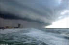 The PNJ's Ben Twingley captured a dramatic view of the clouds over the beach Monday evening. To the left you can see a thumbnail, but visit the PNJ to get the full effect.
Disappointed that the storm surge will barely reach "8 to 10 feet above normal tide levels" at the worst, and Alberto does not look like it will kill hundreds or lay waste to the entire state of Florida, perverse world oil traders drove petroleum prices down below $70 a barrel.
Locally, it will be a red flag day on Pensacola Beach. But most effects of the first tropical storm of the year should dissipate by mid-afternoon, allowing for the scheduled Blues on the Beach performance by ETC at 7 p.m. at the Gulfside Pavillion.


No comments:
Post a Comment