Wednesday, August 31, 2005

Louisiana's Depleted National Guard

"They took my cavalry, man."
-- New Orleans shopkeeper

A 3 p.m. Wednesday update from the New Orleans Times-Picayune carries two anecdotes of interest -- and concern.

First is one among many vignettes concerning stranded New Orleans residents:
For the past two days, a flotilla of small boats commanded by officers with the New Orleans Police Department, Coast Guard, Department of Wildlife and Fisheries, and a smattering of private boats, had been plucking people from oases of safety in what looks like an ocean of water-surrounded rooftops, and brought them to the bridge.

The last of the group arrived around dusk on Tuesday, when the flotilla ceased operations for safety reasons, but the last National Guard truck left at about that same time, and as of 10:30 a.m., no more had arrived.

And that’s got people concerned. When someone drove through the area in a truck towing a boat, a group of people surged around it, screaming at the driver.
Next is a human interest sketch about a local shopkeeper trying to keep his drygoods dry while a customer dropped in, hoping to buy some cigarettes from him:
Robert Buras, whose family has owned the business at Royal and St. Anne for 41 years, smiled.

"I put the smokes up high, so [you should] let the water recede and then come by and yell up to that top window," he said, pointing up to an apartment above and behind the store. "And I’ll throw you down some smokes. But if they’re talking a month before people can come back, it might only be four."

He then turned to another person and said, "I’ve got to ration stuff, you know. All the National Guard that knows how to fight hurricanes is over in Iraq. They took my cavalry, man."
Both stories raise the question, 'So where is the Louisiana National Guard?' Apparently, the answer is most of them are in Iraq.
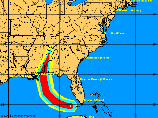
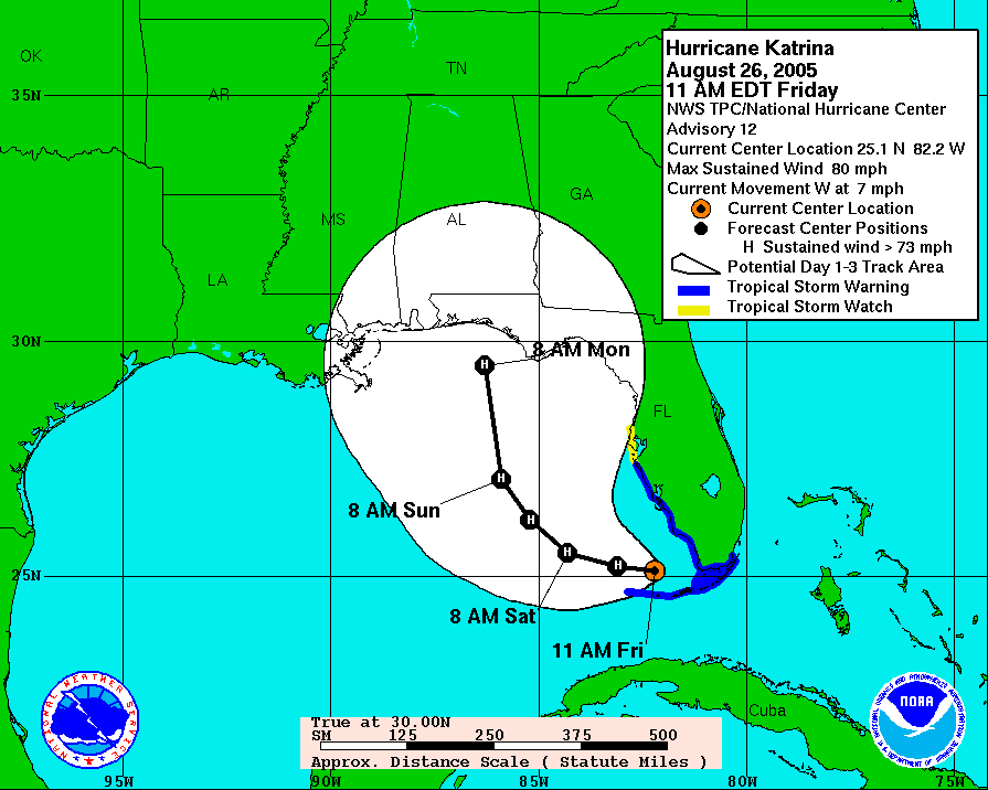
The Louisiana National Guard is on alert, but thousands of guard troops from the state are now serving in Iraq.

[New orleans Mayor Ray] Nagin said 1,500 troops are immediately available, however, and another 2,500 have been mobilized.
In fact, according to a pdf file from an August 2005 Defense Department report, 4,109 Louisiana Army National Guardsmen (and 194 Air National Guard and Air Reserves) are serving in Iraq right now. (4,793 Mississippi and 2,432 Alabama guardsmen also are there). That's more than all but six other states, and nearly half again as many guardsmen as Florida has serving in the war zone.

Louisiana's national guard equipment is in Iraq, too, as Lt. Colonel Pete Schneider of the LA National Guard publicly complained on August 1:
When members of the Louisiana National Guard left for Iraq in October, they took a lot equipment with them. Dozens of high water vehicles, humvees, refuelers and generators are now abroad, and in the event of a major natural disaster that, could be a problem.

"The National Guard needs that equipment back home to support the homeland security mission," said Lt. Colonel Pete Schneider with the LA National Guard.

Col. Schneider says the state has enough equipment to get by, and if Louisiana were to get hit by a major hurricane, the neighboring states of Mississippi, Alabama and Florida have all agreed to help.

"As Governor Bush did for Ivan, after they were hit so many times, he just maxed all of his resources out, he reached out to Louisiana and we sent 200 national guardsmen to help support in recovery efforts," Col. Schneider said.

Members of the Houma-based 256th Infantry will be returning in October, but it could be much longer before the rest of their equipment comes home.

"You've got combatant commanders over there who need it they say they need it, they don't want to lose what they have, and we certainly understand that it's a matter it's a matter of us educating that combatant commander, we need it back here as well," Col. Schneider said.
On Tuesday, Florida began mobilizing "more than 500 Florida National Guard troops" for duty in Alabama, Mississippi, and Louisiana. Altogether, The New York Times reports, "Nearly 11,000 National Guard troops were being deployed in Louisiana, Mississippi, Alabama and Florida." Obviously, a majority of them are from neighboring states.

Well, it's a start. But wouldn't it be more humane, and isn't the need more compelling -- and don't we owe it to them for their service -- to bring the troops home now?

The Coming 'Katrina Economy'

The riveting post-Katrina pictures everyone is seeing... are not the end of some regional storm story. They are the beginning of a wider, longer lasting economic catastrophe that will affect the entire nation and the world beyond.
Almost before Katrina made landfall and well before the full extent of Gulf Coast destruction began to be appreciated, financial analysts were holding forth about the impact Katrina would likely have on the U.S. economy. Their attention, predictably, was focused largely on the certain rise in oil prices and the consequent slowdown in growth.

On Monday, for example, this was Michael Connor's lede for Reuters News Service:
Hurricane Katrina may sting U.S. economic growth by choking energy supplies even as the damages caused by the storm spur massive rebuilding and emergency government spending.

Economists, while emphasizing that few concrete damage assessments have yet been made, said the major hurricane that struck the country's key Louisiana energy gateway would help sustain high oil, gasoline and natural gas prices.
To be sure, the White House decided this time to allow oil companies to borrow from the emergency oil reserve (instead of dawdling for two weeks, as it did after Hurricane Ivan). Even so, crude oil has hit $70 a barrel, sending gasoline in many areas of the nation above $3 a gallon. Why? Because borrowing oil from the U.S. Petroleum Reserve is useless if you can't refine it or transport it.

In the U.S., "There's no question gas will hit $4 a gallon," CNN reports one analyst is saying. He adds: "The question is how high will it go and how long will it last?"

The New York Times, via the International Herald Tribune offers an equally bleak vision about how Katrina will affect air transportation:
Katrina crippled oil and gas operations in the Gulf and shut down most of the output from the region, which accounts for nearly a third of domestic oil production and a fifth of natural gas output. It also forced the closing of nearly 10 percent of U.S. refining capacity, which is concentrated in Mississippi and Louisiana.

The hurricane also shut down a major oil-import terminal in Louisiana with a daily capacity of one million barrels, about 10 percent of the United States' overall imports. Pipelines to markets in the Northeast and the Midwest also are closed. Power will have to be restored before they can resume supplying markets outside the area.

The supply crunch is already rippling through the economy. The Air Transport Association estimated that jet fuel production was cut by 13 percent because of the hurricane.
A New Zealand Newswire Service sees negative worldwide implications for food supplies (and prices) as well:
With towns flattened, Mississippi ports blocked, coastal refineries starved of crude and oil production in the Gulf of Mexico virtually at a standstill, Katrina has had a devastating effect.

* * *
...Peter Zeihan, senior analyst at Stratfor, a global economic and political consultancy in Austin, Texas... [said] "The big question is how much the rivers and ports have been silted up. It could be fixed in two days, it could be two months... ." If it's the longer end, we're going right into the grain harvest. The US is the biggest grain exporter in the world, and most of those exports go down the Mississippi. So food and feed prices could soar worldwide," he said.
In today's Los Angeles Times, James S. Granelli examines some "less obvious ways" Katrina could affect the national economy. In addition to the widely-repeated (and undoubtedly underestimated) $25 billion insured property damage price tag, he contemplates the effects of "$7 billion to $10 billion" in uninsured losses "that will wipe out some homeowners and businesses" as well as cripple ports, bulk produce transportation, commercial fishing and tourism.
New Orleans and its environs wield considerable economic clout. * * * The city's port is a key entryway for bulk commodities, such as coffee and steel, and an outlet for grain exports from the nation's heartland.

Moreover, New Orleans is a major hub in the Gulf Coast's rail and highway network, a big commercial fishing center and a key tourism and convention city.
Yet, Granelli says, "most experts predict only a modest decline — about a quarter of a percentage point — in the nation's growth."

That is hard to believe. Soon, no doubt, economists will be revising upwards their estimates of Katrina's devastating impact on the American economy.

Consider recent employment numbers for the Gulf Coast areas most deeply affected -- completely destroyed, in fact -- by the storm. 601,000 people were employed in New Orleans according to the 2001 Metropolitan statistical update by the U.S. Census Bureau. Almost 83,900 were employed in the Lake Charles area... and 78,000 in Houma. For the metro area of Biloxi-Gulfport-Pascagoula, the number was more than 148,000 employed.

What's likely to happen to the U.S. economy after nearly one million jobs were either blown away by Katrina's winds or are sinking beneath the water that now floods New Orleans? These aren't just oil industry and convenience store jobs. They include virtually every kind of job in the entire Gulf Coast economy, from flipping hamburgers to flipping stocks and from CEOs running entire corporations to cabbies running taxis.

Indeed, every single job in the Dictionary of Standard Occupational Classifications is going to be affected by Katrina. And beyond the jobs which are known to the Government, more damage will be done by the disappearance of a wide variety of quasi-legal 'shadow economy' jobs and their close cousin, the 'blackmarket' and illegal occupations.

The South may boast it is more 'religious' and 'patriotic' but it sure doesn't act much holier or law-abiding than anywhere else. As with the rest of the nation, it can be comfortably surmised that both kinds of "cash economies" -- the so-called shadow economy and the undeground economy -- were thriving equally in the playground of New Orleans, on the staid streets of Mobile, in the casinos of Biloxi, and at all points in between. As D.A. Barber has written:
This underground economy goes beyond the homeless collecting aluminum cans or clogging day labor halls. It includes the working poor getting cash for all forms of recycling: giving plasma, selling homemade tamales outside shopping plazas, holding yard sales, doing under-the-table work for friends and family, selling stuff at pawnshops, CD, book and used clothing stores, and even getting tips from restaurants and bars--to name a few.
Although no one can be certain, it's been estimated by some that in the United States the underground economy "doubled from 4 percent of GDP in 1970 to 9 percent in 2000." Barber reports the IRS "estimates the underground economy is anywhere from 3 to 40 percent of the above ground economy." All of that cash turned around quickly and was plowed back into the 'official' Gulf Coast economy. That is, it was until now.

The riveting post-Katrina pictures everyone is seeing on their television screens or in the daily newspaper are not the end of some regional storm story. They are the beginning of a wider, longer lasting economic catastrophe that will affect the entire nation and the world beyond.

New Orleans Being "Depopulated"

Wednesday morning's Times-Picayune, which is for the moment only being published on-line, reports:
New Orleans became an unimaginable scene of water, fear and suffering Tuesday after a levee breach in the 17th Street Canal sent billions of gallons of Lake Pontchartrain coursing through the city.

As the day wore on, the only dry land was a narrow band from the French Quarter and parts of Uptown, the same small strip that was settled by Bienville amid the swamps.

On Tuesday night, it appeared the city was returning to swamp when a daylong effort to shore the levee near the Hammond Highway failed.

Mayor Ray Nagin said pumps were being overwhelmed and warned that a new deluge would bury the city in up to 15 feet of water.

With solid water from the lake to the French Quarter, the inundation and depopulation of an entire American city was at hand.
There's more here.

Evacuating Pets

Credit: Vincent Laforet, New York Times New Orleans Photos

Never again let anyone tell you they "can't" take their pet with them when they evacuate.

Gulf Coast Disaster Album

New Orleans
Photo credit: U.S. Coast Guard, Petty Officer 2nd Class Kyle Niemi

On the front web page of the Pensacola News Journal you'll find more than a hundred gripping Katrina photos along the entire Gulf Coast from Pensacola Beach to New Orleans (with a handful from south Florida thrown in for good measure).

Tuesday, August 30, 2005

Beach Open

From Escambia County Emergency Management:
Pensacola Beach/SRIA:
* SRIA offices are open.
* Please remember that if there is a red flag posted on the beach, stay out of the Gulf of Mexico. If a yellow flag is posted, please exercise extreme caution when swimming in Gulf.
* As of 2:30 pm Tuesday, Pensacola Beach is now open to residents, business owners and their employees, and contractors and their employees with proper identification and credentials. The beach will open to the general public tomorrow at noon, Wednesday, August 31.

Escambia Schools Closed Wednesday

The Pensacola News Journal is reporting that Escambia County Schools will not have Wednesday classes, due to a lack of power.

All Santa Rosa County schools will resume on Wednesday.

Navarre Beach Katrina Photos

The Santa Rosa County School District has posted a handful of Navarre Beach 'Katrina photos' on its web site. Click here.

Also this notice:
Navarre Beach access is restricted to residents (With proper beach identification) only. (Four-Wheel Drive for residents is strongly recommended.)

Beach Bridge Likely To Open Late Today - Updated

Update
Late afternoon rumors are that beach access will continue to be denied until Wednesday. County road crews still have not completed road clearing.

Earlier


As of 2 p.m. Tuesday, the Bob Sikes Bridge to Pensacola Beach remains closed. But deputy sheriffs directing away expectant traffic say they anticipate the bridge to be opened around 4 p.m.

"We're waiting for George Tuart to inspect the bridge and give his okay," a deputy explained.

Touart is the Escambia County administrator; a politician, not an engineer. Presumably, he will be relying on the report of structural engineers.

Another deputy reported that residents may be allowed to drive to their homes at once if county road plows have cleared beach streets sufficiently. Via De Luna and Ft. Pickens Road are said to be in relatively good shape, but "a lot of sand" over-washed Ariola and Maldonado streets, he explained.

A Central Storm Truth

Beach Boulevard House (Gulf Breeze)
Damaged While Under Construction

Not to minimize the pain of those in the Pensacola area who suffered property damage or personal injury in yesterday's marathon tropical force winds, but Escambia County Sheriff Ron Nesby gave voice to a central truth about the beach in an Associated Press dispatch:
"You don't have the same things out there to destroy now that you would have just in a once-every-five-year storm. Most of the weakened structures were destroyed by the second storm."
Indeed. You can't claim structural or personal property damage when you no longer own a structure or personal property.

Local Storm Recovery Actions - Updated 2

Back in Pensacola, Joanne Harding said Katrina, which was the sixth hurricane to hit the state since Aug. 13, 2004, resolved any second thoughts she and her husband may have had about moving to the Nevada desert.

"This finished it," she said but added "Ivan wasn't so bad. It was being raped by the insurance companies. I've got boarded up windows from Ivan and the insurance companies are still fighting it."


Pensacola Beach and Gulf Breeze residents are being urged to boil water before drinking.

Update: At least one reason is power at the downtown Pensacola Sewer Plant reportdly failed during Hurricane Katrina. Pensacola Bay water flooded the streets, surrounded the plant, and caused raw sewage to "bubble from low-lying lift stations and manholes downtown."

The News Journal is reporting at mid-day that "one out of 10 gas stations in the Panhandle, from Escambia County west to Jackson County, are out of fuel.

Another 40 percent of stations are short on low-octane grades."

The I-10 bridge over Escambia Bay may be reopening as of noon on Tuesday, depending on the results of an engineer's inspection.

Links to closings, bridge reports, detours, power status, and more are now available on the Escambia County Emergency web site. They're promising to keep the info up to date. We shall see.

Of special note:
Pensacola Beach/SRIA

  • Pensacola Beach is closed until further notice.
  • Bob Sikes Bridge is being evaluated by Florida Department of Transportation.
  • When Pensacola Beach is deemed safe, it will open to residents, business owners and contractors with proper identification and credentials (i.e. annual beach passes for residents, licenses for contractors.)
While Penasacola's Channel 3 has revereted to its usual abysmal daytime programming, WKRG-TV in Mobile continues doing a fine job of updating post-storm warnings, closures, cancelations, etc., in Florida, Alabama, and Mississippi.

Here's a sample, as of 10:30 Tuesday:

Navarre Beach access is restricted to residents (With proper beach identification) only. (Four-Wheel Drive for residents is strongly recommended.)

Interstate-10 Bridge in Escambia County, Fla. closed; motorists traveling I-10 Eastbound use this detour: Highway 29 North (Exit 10A) to Highway 4, east to State Road 89, south to State Road 87, south to Highway 90, east to State Road 87, south to Interstate 10.

Interstate 10 - Both the eastbound and westbound lanes are open from the Florida to the Mississippi line.

There's more here.

A Memory of Last Island


Excerpted from A Memory of Last Island, by Lafcadio Hearn (1850 - 1904), first published in 1889
Day breaks through the flying wrack, over the infinite heaving of the sea, over the low land made vast with desolation. It is a spectral dawn: a wan light, like the light of a dying sun.

The wind has waned and veered; the flood sinks slowly back to its abysses--abandoning its plunder -- scattering its piteous waifs over bar and dune, over shoal and marsh, among the silences of the mango-swamps, over the long low reaches of sand-grasses and drowned weeds, for more than a hundred miles. From the shell-reefs of Pointe-au-Fer to the shallows of Pelto Bay the dead lie mingled with the high-heaped drift; from their cypress groves the vultures rise to dispute a share of the feast with the shrieking frigate-birds and squeaking gulls. And as the tremendous tide withdraws its plunging waters, all the pirates of air follow the great white-gleaming retreat: a storm of billowing wings and screaming throats.

And swift in the wake of gull and frigate-bird the Wreckers come, the Spoilers of the dead, savage skimmers of the sea, hurricane-riders wont to spread their canvas-pinions in the face of storms; * * * smugglers by opportunity -- wild channel-finders from obscure bayous and unfamiliar chenieres, all skilled in the mysteries of these mysterious waters beyond the comprehension of the oldest licensed pilot ... .

There is plunder for all -- birds and men. There are drowned sheep in multitude, heaped carcasses of kine. There are casks of claret and kegs of brandy and legions of bottles bobbing in the surf. There are billiard-tables overturned upon the land;--there are sofas, pianos, footstools and music-stools, luxurious chairs, lounges of bamboo. There are chests of cedar, and toilet-tables of rosewood, and trunks of fine stamped leather stored with precious apparel. There are objets de luxe innumerable. There are children's playthings: French dolls in marvellous toilets, and toy carts, and wooden horses * * * There is money in notes and in coin -- in purses, in pocketbooks, and in pockets: plenty of it! There are silks, satins, laces, and fine linen to be stripped from the bodies of the drowned, -- and necklaces, bracelets, watches, finger-rings and fine chains, brooches and trinkets ...

* * *
... Suddenly a long, mighty silver trilling fills the ears of all: there is a wild hurrying and scurrying; swiftly, one after another, the overburdened luggers spread wings and flutter away.

Thrice the great cry rings rippling through the gray air, and over the green sea, and over the far-flooded shell-reefs, where the huge white flashes are,--sheet-lightning of breakers,--and over the weird wash of corpses coming in.

It is the steam-call of the relief-boat, hastening to rescue the living, to gather in the dead.

The tremendous tragedy is over!

Before Armageddon...

Courtesy of CTV.com

If you live on Pensacola Beach, before Armageddon be sure to stop by Blockbuster and rent a few videos.

From Tuesday morning's Pensacola News Journal:
At noon, Newkirk held onto a wooden rail at the top of his 35-foot-tall lookout tower and watched the effects of the storm make their final push through the beach.

"It really hasn't been that bad," he said.

Newkirk's wife, Susan, and his daughter, Christy, were watching the movie "Million Dollar Baby" and waiting for the winds to subside. The family dog, Sinbad, sat in the front yard and barked as winds reaching 50 mph howled.

"I haven't been able to get him to come inside,'' Newkirk said.

* * *
At the eastern end of the island on Panferio Drive, Burt Graham also rode out the storm in his beach home. He still had power at 1 p.m. Monday. His wife watched a movie inside while he monitored the beach from his deck.

Video of Katrina

Tueday's New York Times has video and still pictures of Katrina from New Orleans, Gulfport, Mobile, and other Gulf Coast sites. Click this link and scroll down to "Photos and Video." (Free Registration required.)

Monday, August 29, 2005

While The Power Was Out


Of course, we had flashlights in hand -- or
strung around the neck of those without hands.

For about the last twenty-five hours, tropical force (and near-tropical force) winds whistled over and through Pensacola Beach and nearby areas. It's too early to assess the damage. Darkness has fallen now, anyway. All that can be done for the moment is give a highly personal, impressionistic picture of what this day was like for Pensacola... Gulf Breeze.... Navarre Beach... and other nearby coastal communities.

Most everyone knew Hurricane Katrina was going to miss Northwest Florida by a couple of hundred miles. Yet, we knew the prognosticators might be wrong and that, in any event, they said we'd probably experience tropical force winds for a few hours. The people one met standing in line at the store, or waiting for gas at the few stations that still had any fuel, all knew the drill. They were ready, we were ready. For anything. Or so we thought.

But, a very, very large tropical storm, even one that merely grazes your area, is harder to endure than many imagined. You are cooped up without power for hours and hours on end while winds whistle outside the door, mysterious things go bump-bump on the roof, rain squalls of fine needle-like droplets rattle the windows, and the mid-day skies turn as dusky as late evening.

Of course, we had flashlights in hand -- or strung around the neck of those without hands. And there was Scrabble or Yahtzee to be played by the oldsters, and Gameboys for the youngun's. But ceaseless tedium and anxiety take their toll. Dogs snap at each other. People snap at each other. People snap at dogs.

Interestingly, dogs don't snap at people. As Roald Amundsen knew intutively, and Robert Scott did not know to his everlasting regret, the company of dogs makes even the terrible tribulations of an Antarctic winter -- and now we can say, Gulf hurricanes, too -- bearable for human beings.

Weather news was easier to come by during this storm than ever before, even when the power went out. This is thanks to simulcast agreements among the various local television and radio stations (first attempted here during Hurricane Ivan) -- plus a lifetime supply of household batteries in every size and shape which we have accumulated over the past year as each new storm entered the Gulf.

Some radio stations carried local Channel 3 (WEAR-TV, Pensacola). Others carried Channel 5 (WKRG-TV, Mobile). Between the two, we were as well informed about the storm's progress as anyone outside the National Hurricane Center -- but equally impotent to do anything about it.

(The only serious disappointment in electronic media coverage occurred in the wee hours of Monday morning when Pensacola's Channel 3 ceased its generally good live broadcasting and reverted to the station's execrable lineup of "info-mericals." This time, they featured some sort of beauty skin treatment and a Pensacola pawn shop that seems to specialize in shotguns and bulldozers. (That's Sinclair Broadcasting for you. An FCC-endorsed monoply and proud to take advantage of it.)

Cell phone service went in and out all day long. Mostly it was out. (Text messaging works better at times like these.) The power cut in and out, too, for a time before disappearing altogether.

Some neighborhoods lost power early Sunday evening. Others lost it early Monday morning and didn't see it return for many hours. (It took three four five tries to upload this message). We hear that about 100,000 homes in the two county area were left without power. Ours was one of them.

All kinds of other rumors, none verified as yet, started sweeping the county the moment the worst was over -- about 6 p.m. The beach did fine... the beach was inundated for a time beneath the waves. The wind tore off roofs... No, the wind wasn't that bad. Downtown Pensacola was flooded (it really was -- check the video available on the Pensacola News Journal web site). Navarre Beach was devastated (it may have been). Pensacola Beach did well.

This last is highly doubtful, but it is a common fib put out after nearly every storm to attract whatever dotty tourists remain who may be still thinking of vacationing at Pensacola Beach instead of, say, Baghdad or Darfur.

The one characteristic of Hurricane Katrina that may be the most lasting is this -- it was the most lasting. That is to say, it was a very, very large storm that stayed around a very, very long time. Long enough for pre-storm anxiety to morph into healthy fear at the first sign of winds; then into awe at the storm's power and then into wonder at the sharp needle-like sheets of horizontal rain; and then concern for how much longer any building could withstand such a prolonged, ceaseless assault; and finally -- into boredom, fatigue and lassitude.

The cheese curls were gone. The potato chips were reduced to a handful of salt slivers in the bottom of the bag. Among the cookies, but one soggy chocolate chip cookie remained.

"If this storm keeps blowing," someone said, "pretty soon we'll have to eat real food."

Finally, about 9:30 p.m. Monday evening, some 25 hours after the winds had first picked up to confirm that Pensacola would be on the far eastern edge of Hurricane Katrina, as predicted, the lights came on and the wind died away.

Wearily, we breathed a collective sigh of relief. We gently took the headlamp off the neck of the dog. Then we stowed it away in the cupboard -- for the next time.

Katrina Targets Big Easy


Close-up of Page 1

Full web site of New Orleans Times Picayune

Sunday, August 28, 2005

Katrina Before Landfall


Okaloosa County, Fl., Sunday night canceled all emergency evacuation orders, according to local radio reports.

Media Links for Katrina News

Pensacola: WUWF-FM (independent news coverage plus audio simulcasting with local TV station WEAR-TV, Ch. 3)

Pensacola Beachcam: WEAR-TV's beachcam atop South Harbor Condominium in the central commercial core.

Mobile, AL: WKRG-TV webcasting live

For New Orleans:
WWL-TV, New Orleans Ch. 4 webcasting

Katrina Sustains Strength

Morphed 12-hour Intensity Image
Courtesy CMISS of the University of Wisconsin

The 4 pm NHC advisory has nothing but bad news.
  • Katrina continues moving Northwest toward New Orleans at 13 MPH

  • Forecasts continue calling for "a gradual turn to the North "over the next 24 hours"

  • Conditions along the entire northern Gulf coast are deterioriating rapidly "and are expected to worsen through the night"

  • Maximum sustained winds remain about 165 mph

  • The eye of Hurricane Katrina is not expected to approach the coast until early Monday morning, as a Category 4 or 5

  • The storm is very large with "hurrican force winds" extending "outward up to 105 miles from the center... and tropical storm force winds extend outward up to 230 miles"

And, from the NHC advisory writer there is this somewhat odd coda:
"WINDS AFFECTING THE UPPER FLOORS OF HIGH-RISE BUILDINGS WILL BE SIGNIFICANTLY STRONGER THAN THOSE NEAR GROUND LEVEL."

Eywitness Report

Another message from a reader. As of 1 p.m. Sunday, Soundside water near Quietwater Beach had risen to the edge of Pensacola Beach Boulevard (near the tollgates). Earlier, it was officially reported that Gulf water had breached Ariola Drive (the Gulfside street).

Local media now are reporting a water surge of "10 to 12 feet" can be expected in the immediate Pensacola-Gulf Breeze-Pensacola Beach vicinity, even if Hurricane Katrina continues tracking toward New Orleans.

Escambia Finally Orders Mandatory Evacuation

Sunday afternoon, Escambia County Emergency Management finally ordered mandatory evacuation of "people in low-lying areas, mobile homes and travel trailers."

Coincidentally, perhaps, it happened only after the first, drenching rain squall came racing through Pensacola Beach and Gulf Breeze at 1 p.m. and a formal statement was issued by the president of the United States. (A statement, one must add, spoiled only by Mr. Bush's "Grade F" effort to minimize another brewing storm in Iraq.)

Area Evacuations and Storm Surges

Local television station WEAR-TV reported at 11:45 a.m. that a storm surge of 8 to 10 feet now is expected in Escambia County coastal areas.

Navarre Beach is under a Santa Rosa County mandatory evacuation order for "all waterfront areas and all residents who live within one quarter mile of a water body... ."

A new publication calling itself the EscaRosa Press reports that:
Evacuation of Navarre Beach is in progress due to broaching of Gulf Boulevard by wave action. All residents and guests of Navarre Beach are advised to seek shelter. Sheriff Department and Fire Department personnel are proceeding door-to-door on Navarre Beach to advise residents of the need to evacuate the beaches.
Okaloosa County announced evacuation plans yesterday in a pdf file on its web site:
"Voluntary evacuation begins at noon on Saturday with mandatory evacuation at 6 a.m. on Sunday. Evacuation orders include all coastal areas surrounding U.S. Highway 98 and near Choctawhatchee Bay, all barrier islands, trailer parks, campgrounds and flood-prone areas.
Local television and radio stations report that the City of Destin has ordered mandatory evacuation of coastal areas, but no link is available yet.

Escambia County is opening select storm shelters. There still is no word as yet about mandatory evacuations for low lying areas.

County Dithers While Island Roads Flood

We've received another email from a reader:
"We have decided to evacuate from the island even though there is no official word yet that we know of - mainly because the expected Gulf storm surge of 5 - 7' threatens our vehicles with inundation. Water is already starting to overwash Ariola Drive (road right next to the beach)."
The web site of the Escambia County Emergency Operations Office verifies "Rising water and flooding conditions are occurring along Pensacola Beach and Perdido Key."

Even so, only voluntary evacuations are being urged at this time:
As of 9:00am, Escambia County officials are urging the residents of Pensacola Beach and Perdido Key to evacuate.

People in low-lying areas, mobile homes and travel trailers should be ready to evacuate quickly if evacuations are expanded.
Local television stations are reporting that ECUA will shut off water to Pensacola Beach at 8 p.m. tonight.

The Santa Rosa Island Authority has yet to be heard from.

Shorter Katrina

National Hurricane Center

From Amy Sowder of the PNJ:
"The west end of the Florida Panhandle remains part of the potential strike zone for Hurricane Katrina, which has grown in strength to a Category 5."

Camille - A Reminiscence

Katrina Sunday Morning - 9:45 a.m.

Media weather experts Sunday morning are all comparing Katrina with Hurricane Camille, which came ashore at Pass Christian, Louisiana, August 17, 1969. It is an apt, but perhaps understated, parallel. Camille was a Category 5 storm with sustained winds of 180 m.p.h. or more. In diameter, however, it was a much smaller storm than Katrina appears likely to be -- at least at this moment.

This morning, a reader sent us a second-hand reminiscence of Camille that drives home the gravity of the storm now bearing down on the Gulf Coast:
Katrina is a monster storm, much larger (wider) and likely more devastating than the historic Camille -- also a Category 5 storm, as is Katrina now.

I am too young to remember Camille. But I heard a Camille story from an old timer on [Pensacola] Beach ten years ago. I had hired him to help repair damage from Hurricane Opal.

In 1969, he was a young man in his twenties and out of work, he told me, when Hurricane Camille hit Louisiana. It not only flattened buildings, he said, but dug up all the cemeteries, too.

After the storm passed, he was able to pick up a job driving a dump truck in Biloxi. And he was glad to have it at the time.

Biloxi is maybe 30 or 40 miles east of where the storm came ashore. The guy told me that for six months it was sheer devastation everywhere there. No trees, roads, no buildings, no cemetaries, even. Absolutely all familiar landmarks were gone.

Hundreds of dump trucks were enlisted to begin the clearing of storm debris. They would drive up in a tight line to a group of bulldozers to receive their loads of loose debris. Then they would form a convoy and head out, in a long, single-file line, so as not to get lost among all the piles of rubble. Back and forth, back and forth they went -- seven days a week for months.

In the trucks ahead of him, he told me, he would often see detached arms and legs and even heads rolling around in the debris and dropping off onto the ground. There were so many dead bodies and so many uprooted cemetaries he couldn't tell if the body parts were from "old" corpses or new ones.

The job lasted for six months. He said as poor as he was then, the job wasn't worth it and he was sorry he had done it. It gave him nightmares for years after that.

It may not happen like that this time. One hopes the Mississippi delta can weaken this storm. But if Katrina hits New Orleans head on, it's likely to be a living nightmare for many thousands of people for years to come.

County Urges Voluntary Evacuation

As of 9 a.m. Sunday morning, the News Journal reports:
Escambia County officials began urging the residents of Pensacola Beach and Perdido Key to evacuate. People in low-lying areas, mobile homes and travel trailers should be ready to evacuate quickly if evacuations are expanded.
No more is available than this as of 9:33 a.m. CDT.

We Get Email

The following is from a Pensacola Beach resident who is, for the moment, still on the beach as of 9 a.m. Sunday:
"Had an automated phone call about 15 minutes ago from Escambia County Emergency Management saying the storm was expected to make landfall in LA but due to its size, we should expect surge to 5 -7 ft. - saying 'this is half of what we experienced during Ivan'. And to please stay tuned to TV, radio etc.. BUT NOT A WORD about evac - not even voluntary.

Now that is REALLY a lot of help - scaring us to death with pics of our cars getting inundated up to the windows, but nothing about suggesting we leave??????? All this did was create extreme confusion on our part.
Escambia Emergency officials -- Where are you?

NW Florida "Local Statement"

Just before 8 a.m. the National Hurricane Center issued a Local Warning Statement for Northwest Florida that may at long last bring to an end the inexplicable dithering of emergency officials in Pensacola and at Pensacola Beach.

The statement reads in pertinent part:
PRECAUTIONARY/PREPAREDNESS ACTIONS...RESIDENTS OF ...NORTHWEST FLORIDA AND SOUTHEAST MISSISSIPPI NEED TO MAKE PREPARATIONS TODAY FOR A MAJOR LAND-FALLING HURRICANE ALONG THE EXTREME SOUTHEASTERN LOUISIANA OR SOUTHWEST MISSISSIPPI COAST MONDAY AFTERNOON. HURRICANE AND TROPICAL STORM FORCE WINDS WILL LIKELY OCCUR WELL EAST OF THE STORM CENTER ...ALONG WITH MODERATE TO HIGH STORM TIDES ALONG THE ALABAMA AND NORTHWEST FLORIDA COASTAL AREAS. ANY EVACUATION DECISIONS FOR COASTAL ALABAMA AND FLORIDA ARE EXPECTED TO BE MADE SOON.

* * *
KATRINA IS EXPECTED TO MAKE LANDFALL SOMEWHERE NEAR SOUTHEAST LOUISIANA AS A MAJOR HURRICANE. WHILE THE EXACT LOCATION OF LANDFALL IS STILL UNCERTAIN AT THIS TIME...A SIGNIFICANT AND LIFE THREATENING STORM TIDE IS EXPECTED TO BE FELT WELL EAST OF THE STORM'S CENTER.

A STORM TIDE OF 6 TO 8 FEET IS EXPECTED ALONG THE EXTREME NORTHWEST FLORIDA COASTLINE. TIDAL WATERS WERE REPORTED WASHING OVER SANTA ROSA ISLAND THIS MORNING.
The statement adds that winds "around 15 to 20 mph" inland and "20 to 30 mph" nearer the Norhtwest Florida coast "with higher gusts" can be expected Sunday afternoon.

KAT Becomes A Cat 5


In a special advisory released at 7 a.m. CDT Sunday, Hurricane Katrina officially was designated a Category 5 storm.
THE PURPOSE OF THIS SPECIAL ADVISORY IS TO REVISE THE INTENSITY OF KATRINA TO CATEGORY FIVE. AN AIR FORCE HURRICANE HUNTER AIRCRAFT REPORTED A PEAK 700 MB FLIGHT-LEVEL WIND OF 153 KNOTS...WHICH CORRESPONDS TO MAXIMUM SURFACE WINDS OF ABOUT 140 KNOTS. OBVIOUSLY...THE BIG QUESTION IS HOW STRONG KATRINA WILL BE AT LANDFALL. WE HAVE VERY LIMITED SKILL IN PREDICTING THIS. FLUCTUATIONS IN INTENSITY...DUE TO EYEWALL R EPLACEMENTS... ARE LIKELY DURING THE NEXT 24 HOURS. NEVERTHELESS... KATRINA IS EXPECTED TO BE A DEVASTING CATEGORY FOUR OR FIVE HURRICANE AT LANDFALL.

Earlier, NHC found the storm's "wind field" had expanded. Consequently, the forecast advisory area for expected tropical force winds also was expanded. It now stretches from western Louisiana all the way to near Apalachicola, Florida:
A TROPICAL STORM WARNING AND A HURRICANE WATCH ARE IN EFFECT FROM EAST OF THE ALABAMA/FLORIDA BORDER TO DESTIN FLORIDA...AND FROM WEST OF MORGAN CITY TO I INTRACOASTAL CITY LOUISIANA. A TROPICAL STORM WARNING MEANS THAT TROPICAL STORM CONDITIONS ARE EXPECTED WITHIN THE WARNING AREA WITHIN THE NEXT 24 HOURS. A HURRICANE WATCH MEANS THAT HURRICANE CONDITIONS ARE POSSIBLE WITHIN THE WATCH AREA... GENERALLY WITHIN 36 HOURS.
With that announcement, it seems all but certain the Pensacola area will suffer at least some serious damaging effects from what may well become the largest and most powerful monster storm to hit the Gulf Coast in decades -- or ever.

One Degree of Separation


Geographically speaking, Pensacola lies at latitude 30.44N and longitude -87.19W.

Pensacola Beach is at latitude: 30.33N and longitude -87.13W

As of 1 am CDT Katrina was at latitude 25.1N and longitude -86.8W

Gulf Coast Danger

Courtesy of CIMSS at U. of Wisconsin

Hurricane Katrina reached Category 4 status early Sunday morning, according to the Public Advisory of the National Weather Service.

If it stays on a westerly path toward a Louisiana landfall -- still no sure thing as the divergent models, above, show -- tropical force winds will affect the entire Pensacola area and a storm surge of 5 feet can be expected on Pensacola Beach, according to the early home delivery edition of Sundays' Penacola News Journal:
"Even if the unpredictable Category 3 hurricane, expected to reach land Monday possibly as a Category 4 storm, keeps to its projected path, dangerous swells and beach erosion threaten the entire Gulf Coast.

* * *
The National Weather Service issued a hurricane warning from Intercoastal City, La., to the Florida-Alabama state line. A hurricane watch and a tropical storm warning extended from the state line east to Destin.

"There's some very warm water ahead of Katrina," said state meteorologist Ben Nelson on Saturday night. "We could see continued strengthening. Even beyond Category 4 is possible."

At that intensity, storm surge could be dangerous far to the east of landfall. Tropical storm-force winds Saturday night extended out 150 miles from Katrina's eye, the National Hurricane Center reported.

The storm surge in the Gulf-- predicted at about 5 feet for Pensacola beaches -- could stretch hundreds of miles east and west of Katrina's eye. Because of that, and the uncertain direction of the slow-moving storm, Florida emergency officials urged Gulf Coast residents to continue disaster preparation."
As of 1 a.m. Sunday, the probability of Katrina's eye passing within 65 nautical miles of Pensacola within the next three days had risen again to 18%. By comparison, Mobile has a 20% chance and New Orleans 25%.

Saturday, August 27, 2005

Beach Evacuation (updated/corrected)


See late update/correction, below

According to a notice on the web site of the Pensacola News Journal "Evacuations: Mandatory evacuation of low-lying areas, beaches and mobile homes is to begin at 6 a.m. Sunday. Decisions about possible evacuations and other actions will be made in the afternoon."

Typically, on Pensacola Beach a mandatory evacuation is enforced when law enforcement agencies do not allow beach residents, business owners or employees, or visitors to enter the beach. Once you leave, you can't come back until county officials say so.

During a mandatory evacuation, Sheriff substation vehicles patrol the streets with loud speaker announcements. At a later stage, those who remain may be personally approached by deputy sheriffs and even more strongly urged to leave. On occasion, they may ask a truly recalcitrant lingerer to sign a statement acknowledging the risks of staying behind. Whatever its legal efficacy, one supposes it is hoped such a request will have the desired psychological effect of scaring the crap out of you.

NHC storm projections remain rather uncertain. Katrina seemed almost to stall out for a time Saturday afternoon as it underwent changes in the eyewall and quite probably encountered new upper atmospheric conditions which -- so it has been surmised for some days, now -- will steer it in a more northerly or northwesterly direction. Much depends on the storm's forward speed once it begins a more northerly path.

By 4 pm Saturday, the National Hurricane Center was broadening even more the official 'Hurricane Watch' zone. Now, it is defined "westward to intercoastal City Louisiana and eastward to the Florida-Alabama Border."

The eastern edge of the zone is less than 25 miles from Pensacola as the evacuation vehicle travels and just a short swim from the tip of Santa Rosa Island.

The public advisory reads in part:
Reports from NOAA and Air Force Reserve Hurricane Hunter aircraft indicate maximum sustained winds are near 115 mph...with higher gusts. Katrina is a category three hurricane on the Saffir-Simpson Scale. Strengthening is forecast during the next 24 hours...and Katrina could become a category four hurricane later tonight or Sunday.

Hurricane force winds extend outward up to 45 miles... 75 km...From the center...and tropical storm force winds extend outward up to 160 miles.
The NHC Discussion Section adds this:
Katrina should strengthen as it comes out of the concentric eyewall cycle. The GFDL [model forecast] is now calling for a peak intensity of 131 kt {about 141 mph] while the Ships model is calling for 130 kt and the FSU Superensemble 128 kt. The intensity forecast will call for strengthening to 125 kt at landfall...and there remains a chance that Katrina could become a category five hurricane before landfall.
That would put it in a class with Hurricane Andrew or even Hurricane Camille, still the only 'official' Category 5 storm to hit the continental United States.

Update/Correction

A reader from the beach sends this correction/update:
This morning's (Sat.'s) hard copy News Journal had a blurb on Page One just like what you're quoting, and then said "Story, 4A". When you went to the story, it said that SANTA ROSA COUNTY was evacuating low lying areas Sun., but, in a completely separate paragraph, that ESCAMBIA COUNTY decisions would be made in the afternoon. (In fact, this jibes with what I [was told in a]...noon telcon with Escambia Emergency Management's hot line.)

Since then, as you can see by the note on the current PNJ web page, the Santa Rosa County evacs have been put on hold. There also has still been no evacuation ordered in Escambia County, and when I called their Emergency Mgmnt. hot line late this afternoon I was told that following Escambia's telcon with the NHC nothing had changed, still no evacs ordered, and that, in fact, the entire hot line staff was being sent home. When I asked if that were standard procedure, the hot line staffer replied, "Not when a storm is expected here, no." I commented, "WELL, then, that sounds like very good news indeed," and she agreed wholeheartedly.

Since then the only other thing I've heard was on the 10 p.m. WEAR newscast... in which they stated there'd be another meeting of Escambia officials tomorrow (Sun.) a.m. at 10 a.m. re any possible evacuations. I would only read that as being cautionary in case there is any substantial change to the track, which, of course, so far there isn't.

* * * With all the mixed signals coming from the media vs. the county, it's hard to know for sure what to do.

So I really hope the NHC knows whereof it speaks, though I realize these storms can have a mind of their own, especially near landfall.

Kat's Eye

Courtesy of Boatus.com

There is an early sign of a possible "eyewall replacement" going on inside Hurricane Katrina. This could indicate the storm has at last begun its anticipated turn toward the North. It also may raise doubts about the 'consensus' model path predictions.

The possibility exists that all the predictive models are wrong. Computer storm path projections -- especially the 3-day projections -- often have a large margin of error. As the latest NHC Forecast Advisory warns us in shouting capital letters:
"NOTE...ERRORS FOR [Katrina's] TRACK HAVE AVERAGED NEAR 250 NM [nautical miles] ON DAY 4 AND 325 NM ON DAY 5.
The most recent data compiled by the National Hurricane Center, as revealed in the Archives of Strike Probabilities show a slight up-tick in the probability of the center of Hurricane Katrina coming within 65 nautical miles of Pensacola:

Wise Words For Beach Locals


Look to the right on our main page and after scrolling down to "Current Area Weather" you'll see a link to Dereck Ortt's hurricane 'blog', sponsored by the Pensacola News Journal. Ortt is a University of Miami graduate student specializing in marine and atmospheric sciences.

His blog provides succinct and reliable tropical storm updates when events warrant. Last night, after seeing the first indications of a possible Louisiana landfall, he had this highly relevant observation to share with local coastal residents:
"It is very important to remember that a hurricane is not a point. If this track holds, there would be nearly complete destruction for the Mississippi and Alabama coasts as well, as well as tidal surges higher than those experienced in Hurricane Georges for the Pensacola area, because this is expected to make landfall as a category 4 hurricane, while Georges was a category 2 hurricane at landfall.

Please take this hurricane seriously if you live along the northern Gulf Coast.
Metaphorically, we are still in Nature's soup bowl. Just a bit nearer the edge.

Shorter Kat Advisory: Larger, Stronger, Wester


The 8 a.m. EDT National Hurricane Center public advisory:
THE EYE OF HURRICANE KATRINA WAS LOCATED ... ABOUT 180 MILES WEST OF KEY WEST FLORIDA... . MOVING TOWARD THE WEST NEAR 7 MPH... KATRINA IS A CATEGORY THREE HURRICANE... MAXIMUM SUSTAINED WINDS ARE NEAR 115 MPH...WITH HIGHER GUSTS. ... KATRINA HAS BECOME A LARGER HURRICANE. ... TROPICAL STORM FORCE WINDS EXTEND OUTWARD UP TO 150 MILES. ...

Katrina "The Big One?"


Via the estimable Hurricane City Message Board there is this scary graphic from the University of Central Florida

UCF also provides estimated Katrina damages to Florida and other nearby areas.

Gulf Loop Currents

Graphic courtesy of Texas A & M University

This morning, the New Orleans Times Picayune, in a front-page article by Mark Schleifstein, reports that Katrina now has "a path forecast to hit southeast Louisiana on Monday as a Category 4 storm with top winds of 132 mph."

He adds:
National Hurricane Center forecasters were predicting landfall in lower Plaquemines Parish.
Plaquemines Parish is a lightly populated, poorly developed lowland delta at the southern tip of Louisiana, built by eons of Yankee mud flowing down the Mississippi River. Obviously, though no one wishes harm to anyone, if the projection holds and Katrina makes landfall there, it would be one of the better of the bad scenarios imaginable.

Although it's still too early to be sure where Katrina will make landfall, this morning's NHC report titled Hurricane Katrina Strike Probabilities assigns a slightly higher chance to a landfall near New Orleans than to Pensacola.

The really interesting part of Schleifstein's article comes down the column, where he mines this quote from Lixion Avila, a forecaster for the National Hurricane Center:
Katrina is expected to pass over the "loop current," a doughnut-shaped circle of warm water that extends down 200 feet that has broken off the Gulf Stream and is floating in the Gulf.

In his 10 p.m. update, Avila described the movement over the current akin to "adding high octane fuel to the fire."

Such loop currents are believed to be capable of causing the intensity of a hurricane to jump as much as a category or two.

So Avila said he would not be surprised if Katrina reached Category 4 strength before going ashore.

"But we don't have good skills in predicting such changes in intensity," he said. "It could intensify rapidly or weaken rapidly right afterward, or right at landfall."
After the shock of the 1995 hurricane season, Pensacola Beach residents heard from a few experts who shared their fears that some sort of "channel" had been created in the Gulf which might explain why Hurricanes Erin and Opal both made a bee-line for Pensacola Beach. A number of preliminary storm reports by Florida meteorologal students mentioning that possibility also circulated briefly on the beach. It looks like one such report may be available from the American Meteorological Society, which also provides an on-line abstract.

The interaction of atmospheric, surface, and water currents is so complex few can claim the ability to understand all of their implications -- for now. But you have to wonder if those old rumors about Erin and Opal being steered our way by a "hurricane channel" had substance.

For those interested in learning more, apparently the Minerals Management Service has a more extensive report you can order. MMS is a U.S. Gulf of Mexico research center which, as Gulf drilling opponents know too well, devotes a substantial part of its resources to publicly advocating for the petroleum industry with reductio ad absurdum arguments like "oil drilling platforms make good houses for fish."

But their often hefty scientific reports are mind-numbingly thorough, scientific, and reality-based. No "faith based" work there. Not when money's on the line.

Friday, August 26, 2005

Go West, Katrina, Go West

Courtesy of Boatus.com

As of the National Hurricane Center's 5 p.m. forecast, Katrina's projected path has shifted to the West once again. Presently, this would pinpoint landfall just west of Mobile, AL -- a smidgen farther than Ivan but in the same close vicinity.

According to the NHC:
AFTER 24 HOURS... THE MODELS ARE IN GENERAL AGREEMENT ON A SHORTWAVE TROUGH CURRENTLY OVER THE NORTHERN AND CENTRAL PLAINS STATES TO GRADUALLY DIG SOUTHEASTWARD TOWARD THE CENTRAL AND WESTERN GULF OF MEXICO...WHICH ALLOWS KATRINA TO MOVE NORTHWARD BY 72 HOURS. AS A RESULT...THE MODELS HAVE SHIFTED SIGNIFICANTLY WESTWARD AND ARE NOW IN BETTER AGREEMENT.

THIS HAS RESULTED IN THE OFFICIAL FORECAST TRACK BEING SHIFTED ABOUT 150 NMI WEST OF THE PREVIOUS TRACK...ON THE EAST SIDE OF THE GUIDANCE ENVELOPE. HOWEVER... PROJECTED LANDFALL IS STILL ABOUT 72 HOURS AWAY...SO FURTHER MODIFICATIONS IN THE FORECAST TRACK ARE POSSIBLE.
Although there remains substantial uncertainty about the ultimate point of landfall, the NHC seems to be quite certain about the storm's strength:
KATRINA IS EXPECTED TO BE MOVING OVER THE GULF LOOP CURRENT AFTER 36 HOURS...WHICH WHEN COMBINED WITH DECREASING VERTICAL SHEAR...SHOULD ALLOW THE HURRICANE TO REACH CATEGORY FOUR STATUS BEFORE LANDFALL OCCURS.
About this point in the Gulfward progress of Hurricane Ivan -- two days away from landfall -- a dark joke began circulating on Pensacola Beach. It went something like this:
MAN: With this horrible storm bearing down us, how can you be smiling like that?
WOMAN: I'm very hopeful about the storm.
MAN: (Incredulous) Hopeful? How you can you be hopeful?
WOMAN: Well, I think it's very important to remain optimistic. So, I've decided this hurricane is going to go further west and make landfall in New Orleans, killing 3 million people.
Not funny, maybe. But it's an accurate look into our darkest thoughts as we selfishly wish Katrina onward toward the West.

Katrina Klosures


It's not yet on its web site, but about 4:30 p.m. CDT airlines serving the Pensacola airport were advised that all out-bound flights from Pensacola will be grounded early Sunday afternoon through Monday.

Pensacola Junior College and the University of West Florida have announced that classes are canceled through at least Monday. PJC's web master created a clever graphic (above). UWF also will likely be opening the student storm shelter:
In the event Hurricane Katrina continues to track toward Pensacola, student residents who do not leave campus will be moved to the student university shelter. If necessary, the student university shelter will open late afternoon Sunday, Aug. 28. Should the shelter be activated, incoming calls for information on students can be made to 1-866-UWF-NEWS. This number will only be activated if students are required to evacuate to the student university shelter.

* * *
Due to the variance in the projected path of Hurricane Katrina, it is impossible for university officials to determine whether or not UWF will be re-opened Tuesday, Aug. 30.
Also, university radio station WUWF-FM is promising over the air to post closings soon. Meanwhile, those at a distance can tune their computers (with cable or DSL) into live broadcasts on WUWF-FM.

Escambia and Santa Rosa county schools are closed Monday. Courts in both counties have announced they are closing. All trials set for Monday are canceled, but Chief Circuit Court Judge Kim Skievaski "highly" anticipates "that all courts in the First Judicial Circuit will reopen on Tuesday, August 30, 2005."

Other closures are being posted on the web site of the Pensacola News Journal

Katrina's Terrible Timing

It's been nearly 11 and a half months since Hurricane Ivan and 6 weeks since Hurricane Dennis. Pensacola Beach hasn't yet had time to recover from either storm -- although it's been trying, as today's scenes along Va DeLuna show:


Gas Lines Forming

Polyana (don't you just love that name at times like these?) da Costa and Carlton Proctor of the Pensacola News Journal report on line at mid-day that "Panhandle area residents have started to line up at gas stations to fill up their tanks in preparation for Hurricane Katrina."

There's more:
Haruka Umeda, a worker at Raceway, a Gulf Breeze station, said people were buying an average of $100 of gasoline for generators and vehicles. She received a delivery this morning but is not expecting it to last beyond tonight.

Larry Adkinson, owner of a station in Cervantes said traffic has started to pick up at his station as well. He still has 4,000 gallons of gas left, which he expects to last for a couple days.

* * *
"We’re busy, busy, busy," said Stephanie Young, store manager at a Shell station on Mobile Highway. "We ran out last night, but got another truck in about 2 a.m., so we’re in good shape. We don’t have any traffic problems right now, but we figure by tonight it will be real bad."

"We’ve been slammed since 6 a.m.," said Neel Clark, assistant store manager [of a Shell station on Mobile Highway]. ... We’re out of regular gas, but we’ve got plenty of premium."

At the Circle K on Langley Avenue, store clerk Lisa Stacey said they have run out of regular, but have a truck on the way with another shipment.

Unlike the mad rush prior to Hurricane Dennis last month, the good news is that there is plenty of gas product available in the Pensacola area, said Tom Kelly, a spokesman for Radcliff Economy Marine, also know as Mocar.


The daily morning Pensacola News Journal is posting reporters' Hurricane Katrina stories today as they are filed.

Escambia County Declares Emergency

The Escambia County Board of County Commissioners declared a Local State of Emergency today at 10:45 a.m. [CDT] due to the potential of Hurricane Katrina.

Special Advisory: "Kat" To Be A 4

A highly unusual 'special advisory' was issued by the National Hurricane Center at 10:30 a.m. CDT, predicting that Hurricane Katrina will reach Category 4 status in the next two days:
STEADY INTENSIFICATION TO NEAR CATEGORY FOUR STRENGTH BY 72 HOURS APPEARS TO BE IN ORDER GIVEN THE VERY WARM GULF WATERS BENEATH THE HURRICANE AND THE VERTICAL SHEAR FORECAST TO DECREASE TO LESS THAN 10 KT BY 48 HOURS.
Category 4 status means sustained winds of 131-155 mph, extensive roof damage, and likely road wash-outs in low lying areas.

Read the complete list of descriptive symptoms here.

Pensacola A Target Again


The 11 a.m. EDT update on Hurricane Katrina predicts the storm will soon reach Category 2 status with sustained winds of 96-110 mph. It also confirms the projected path has moved farther west from Apalachicola, once again, putting Pensacola near the bullseye.

Things could change -- and likely will. The NHC erred yesterday in predicting Katrina would slowly march across Broward County (Ft. Lauderdale) in crossing the southern tip of Florida. Instead, she hit farther south in Dade County (North Miami) and progressed fairly rapidly over the Everglades while crossing the Florida peninsula. Instead of losing strength over land, the storm actually gained power.

At 11 a.m. EDT Friday, NHC officially inched its 3-day path projection westward, again. It now targets an area nearer Destin. Unofficially, NHC weather pronosticators are being quoted on radio as predicting Hurricane Katrina will be at least a category 3 storm when it makes landfall.

Locally, everybody one encounters seems instantly aware of the latest weather news and nuanced variations in the forecasts. No one is taking any chances. Vehicles are gassing up, the aisles of hardware stores are filled with shoppers, bottled water is flying off grocery shelves.

As you can see in their eyes, the drill is all too familiar to panhandle residents.

Katrina's Wobbly Projections


Hurricane Katrina lost little of its power after hitting North Miami about 7 p.m. and crossing over the "the relatively moist everglades" Thursday night. The Category 1 hurricane is now in the Gulf of Mexico, heading west-northwest.

Early this morning, an NHC meteorologist told National Public Radio's Morning Edition that current projections are it will strengthen and make a second landfall "anywhere from central Florida to the Florida panhandle."

The worrisome thing for Pensacola residents is that official storm projections now are shifting the projected landfall point more westerly away from yesterday's 5-day target of Apalachicola.

First, experts had it headed for Pensacola. Then, they shifted the projection cone toward the east. As of now, the dynamic archive of storm projection models shows a path turning westerly again.

Thursday, August 25, 2005

Katrina's Personality

Photo courtsey of WKMG-TV Channel 6, Orlando

Every tropical storm, it seems, has its own peculiar personality -- at least as experienced on Pensacola Beach.

Erin (Aug. 1995) was windy but relatively dry. Opal (Oct. 1995) was marked chiefly by a devastating water surge. Danny (July 1997) hung over Mobile forever, so it seemed, and actually emptied the bay of water. Georges (Sept. 1998) brought tons of rain and beach-eroding wave action. And Ivan (Sept. 2004)...well, everyone knows what Ivan was like; the evidence is still all around us.

So, what kind of personality does Katrina have? After speaking with state meteorolgist Ben Nelson, the Treasure Coast newspapers report that "Katrina has a large rain field but a small wind field. Tropical storm-force winds expand 70 miles from the center... ."

Governor Jeb Bush today passed along what he was told to expect for South Florida:
Storm surge is less of a concern for Katrina, which is expected to be a Category 1 storm by the time it reaches land, but rain is the biggest problem in the already soggy state, Bush said.

"This system will bring tremendous rain to the peninsula," he said.
That's south Florida, of course. There's no telling what personality defects Katrina may acquire by the time she hits the Gulf Coast early next week -- or where she'll make landfall. But you can follow her closely at Jim Williams' Hurricane City web site and get all the right (and wrong) guesses on the Hurricane City Message Board.

Forecasting Katrina: Follow the Money


Overnight, the official National Hurricane Center's forecast track for T.S. Katrina slipped slightly eastward. We know this not only from the usual 5-day weather cone map, but also because crude oil futures were "little changed" in overnight trading, according to Bloomberg's wrap-up for the European commodities markets:
Crude oil was little changed after reaching a record $68 a barrel in New York as forecasts indicated Tropical Strom Katrina may veer away from U.S. producing areas in the Gulf of Mexico.

Katrina is expected to enter the Gulf after crossing Florida tomorrow and may make landfall in the state's panhandle in three days, according to the U.S. National Hurricane Center. * * *

"It seems like the storm is trailing away," easing concern about an output halt at oil and gas rigs, said Christopher Bellew, a broker at Bache Financial Ltd. in London.
By "trailing away," broker Bellew obviously means trailing away from the west-central portions of the Gulf where the drilling rigs are.

Pensacola still is not entirely out of danger, by any means. As
Sean Smith reports
in today's PNJ:
While the latest five-day forecast has Katrina making landfall near Apalachicola, 150 miles east of Pensacola, the track is far from a sure thing.

"If you take our forecast errors into consideration, it could hit anywhere from Alabama to the Florida Big Bend," said Hugh Cobb, National Hurricane Center meteorologist.
If you've bet all of your frail mother's dough on rising gas prices, there's more good news to come -- another low pressure area between the Cape Verde Island and the Lesser Antilles. According to the National Hurricane Center:
Although this system remains in an area not favorable for further development... the shear is forecasted to relax over the next day or so... Thus there is a possibility of tropical cyclone.
It looks all good if you're betting on rising oil prices.

Wednesday, August 24, 2005

Be A Witness

If you're sick of television's obsession with tangential tabloid tales while ignoring important world news, watch the "Be A Witness" video ad. It's cogent, convincing, and even funny in a bitter, Jonathan Swift way.

Unfortunately, you can only see it on the Internet. The three major networks and two other media conglomerates have refused to sell ad time to the sponsors. So, send a message to CBS, ABC, NBC, Allbritton Communications, and Gannett Corporation to tell them "Genocide Is News."

The "Model Consensus"


At 5 pm Wednesday, August 24, the National Hurricane Center says its computer models:
"... differ signficantly on where and when Katrina is expected to turn Northward and make a second landfall along the Northeast Gulf Coast. The GFDN is the western-most model and takes the cyclone to New Orleans ...whereas the GFS and Canadian models are the easternmost models and take Katrina Northeastward across the northern Florida peninsula. The office track is near the middle of the guidance envelope and close to the model consensus."
And that consensus?

Sure looks like Pensacola.

Katrina To Be A Gulf Hurricane

65 Knots = 74.9 mph

The NHC 11 am EDT forecast for T.S. Katrina calls for it to 'steadily intensify', turn more westerly tomorrow, cross the Florida peninsula, reemerge in the Gulf, and become a hurricane.

The capital-letter shouting is from the National Hurricane Center:
KATRINA... IS EXPECTED TO SLOWLY BUILD EASTWARD...CAUSING THE CYCLONE TO TURN MORE WESTWARD AFTER 24 HOURS AND CROSS THE SOUTHERN FLORIDA PENINSULA. AFTER EMERGING OVER THE EASTERN GULF OF MEXICO IN 72 HOURS...THE WESTERN PORTION OF THE RIDGE IS FORECAST TO WEAKEN AND ALLOW KATRINA TO MOVE NORTHWESTWARD.

* * *

KATRINA IS EXPECTED TO BECOME A HURRICANE PRIOR TO LANDFALL

Andrew Anniversary


August 24, 1992

Tropical Storm Katrina


As feared yesterday morning, a tropical storm has formed near the Bahamas and is expected by the NHC to navigate into the Gulf by this weekend. T.S. Katrina could possibly become a hurricane by Sunday or Monday.

Widely scattered computer model projections early Wednesday show that both the eventual direction and intensity of T.S. Katrina remain uncertain for the time being. However, Pensacola area residents, and particularly barrier island homeowners and businesses, should keep a careful watch on this developing storm.

Slapped in the Face - Again

Slap us once, shame on you. Slap us twice, shame on us.

Florida consumers ought to be feeling a lot like an abused spouse. The serial abuser is the state legislature, this time aided and abetted by Governor Jeb Bush.

Today's PNJ is carrying Paige St. John's latest report about how Florida has shut out the consumer's voice once again when insurance policies are up for discussion. (Free web access to her article will continue for some time at the Ft. Myers News-Press.)

Here's the essence of it:
Consumers don't have a seat on a legislative panel that meets today to take up the problem of helping Floridians get hurricane insurance.

Task force members named this week include some of the loudest voices in Florida for higher premiums, exemptions to wind-resistant building codes, and increased reliance on policyholders to cover insurers' claims after catastrophic storms.

The 12-member Task Force on Long-Term Solutions for Florida's Hurricane Insurance Market includes no consumers.

* * *
The task force was ordered by the Legislature last spring to address issues lingering from the 2004 hurricanes. It is required specifically to look at the thousands of policies major insurers are now turning away, forcing more homeowners into the state-run Citizens Property Insurance.

The legislation requires Gov. Jeb Bush's three appointments to include a voice for "insurance consumers." In that slot, Bush named the president of an insurance-created group that advocates storm shutters and other home-disaster preparation but is silent on controversial matters like rates.


This isn't the first time ordinary consumers have been given the back of the hand by one of Florida's top elected leaders. Last December, Tom Gallagher, the second most powerful Republican official in Florida, appointed a 13-member "Task Force on Policyholder Services and Relations to Citizens Property Insurance." It included everyone but an ordinary consumer.

As with a battered spouse we want to ask, 'Why do these brutes treat consumers like dirt?' But we should be asking, 'How much longer are we going to put up with this abuse?'

Tuesday, August 23, 2005

"Cape Verde" Season

"This is the time of year when people should keep their eye on the forecast in the tropics," according to National Hurricane Center forecaster Hugh Cobb. "We are entering the Cape Verde season."

Graham Brink of the St. Petersburg Times adds:
Late August and early September are historically the most active for tropical storms and hurricanes.

* * *
On average, about 60 waves generate over North Africa each year, according to the National Hurricane Center.

The waves spawn about 60 percent of tropical storms and minor hurricanes that form in the Atlantic Basin - the Atlantic Ocean, Caribbean Sea and Gulf of Mexico. Nearly 85 percent of major hurricanes originate from the waves.
Currently, the National Hurricane Center is keeping one eye on the remnants of former Tropical Depression 10, which may be re-strengthening along the Cuban coast, and the other eye on a strong tropical wave in the far eastern Atlantic.

Monday, August 22, 2005

Tropical Gambling

There's an old poker players' expression. "If you look around the table and you can't tell who the sucker is -- then it's you."

Intrepid investigative reporter Paige St. John nails the Florida Office of Insurance Regulation today for gambling on the weather. The thing of it is, it looks like we're the suckers. The state is gambling with our homeowner's money but it won't tell us about it.
Rather than shut down insurers tottering from last year's hurricanes, Florida regulators are letting them grow with the riskiest policies in the state.

It's a gamble on the weather.

Florida homeowners are on the hook to pay if they lose. There's the promise of a healthier market and, maybe, competition to drive down rates if skies stay blue.
Yeah, right. Lower insurance rates. More like, 'heads you lose, tails they make bigger profits.'

Just last month, we warned of this by asking if Citizens Property Insurance had "depopulated you to a dog?" Now, evidence is surfacing that both state regulators and the state-owned Citizens Property Insurance Corp. have deliberately blinkered themselves against the growing number of Florida property insurance companies that cannot cover losses if there's another hurricane.

St. John explains:
State regulations require property and casualty insurers to have the larger of $5 million capital, or 10 percent of their liabilities. But 2004 storm losses emptied many of those accounts and parent companies and private investors have not put all of it back.

Financial records show at least five companies with thin capital, some under regulatory watch and others with assets inflated by future tax deductions and solvency ratings of "weak" and "marginal."

If companies fail, policyholders recover only losses up to $300,000 through Florida's Insurance Guaranty Association. Homeowners across the state would pay the bill through assessments added to already rising premiums.

* * *
Among those in trouble is Florida's fifth largest insurance holding company, Poe Financial Group. All three of the Tampa-based company's insurance subsidiaries, Atlantic Preferred, Florida Preferred and Southern Family, have ceased allowing their books to be viewed by financial rating companies.
So how can you tell if Florida officials are gambling with your homeowner's insurance? You can't -- thanks to the state legislators you sent to Tallahassee. It's a "state secret."
The Florida Office of Insurance Regulation would not say how many companies fell out of compliance with solvency requirements after the hurricanes, or remain there still. Legislators have made such records confidential, hidden even to policyholders.
In other words, Florida legislators have created a system that even a Biloxi casino would envy. They gamble with your money while protecting what St. John calls "friends and family" insurance companies.

Whose "friends" and "family"? Why, the relatives and buddies of state legislators and insurance industry executives, of course -- as just about any property insurance agent in Florida will tell you.