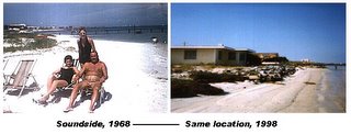
"It's strange; we look just east and west of us and homeowners are losing beach," Charlie Thompson said. "A lot of these docks are sitting over sand."Above the front-page fold in today's PNJ, Sean Smith reports that the National Park Service has ponied up "$50,000 to $60,000" for a University of West Florida study of the "impact of north winds compared to hurricanes" along Santa Rosa Sound.-- Pensacola News Journal, January 5, 2006
This isn't the first such "study" and you can be sure it won't be the last. When it comes to Santa Rosa island, studying and re-studying -- and re-studying again -- is a cottage industry for colleges, academic institutes, coastal engineering firms, consultants, and government agencies.
Think full employment program for geologists and their students.
The SRIA has funded, in part or in whole, at least two such studies of Santa Rosa Sound, alone, in the last ten years. One of them supposedly was intended to measure the effects of a first-ever sand renourishment project along Quietwater Beach. Nothing but a preliminary report ever came of it. The final report (if there was one) has never been released to the public.
The Corps of Engineers launched a major study of island erosion after Hurricane Opal, and a second one in July 2001, in preparation for the Gulf-side sand renourishment project of 2002-03. Results? Who knows? It's not even clear if there was a final report.
The National Science Foundation gave a 5-year grant to Louisiana State University coastal morphologist Dr. Greg Stone after Hurricane Opal. He released a detailed final report in March, 2001. Among other things, it includes surveys -- right down to the centimeter -- of sand deposition and erosion on Pensacola Beach from the time of Hurricane Fredric (1979) through Hurricane Georges (1998). Want to wager if any board member on the Santa Rosa Island Authority or the Escambia County Commission has read it?
The State of Florida issued both a preliminary and a final coastal erosion report covering the same topic after Hurricanes Opal and Erin in '95. Odds are no one in any department of Escambia County could find a copy if you gave them a week.
Another Florida agency regularly compiles erosion data on all Florida coastal lands using aerial and GPS satellite measuring devices. They visit every coastal area in the state at least once every five years, often more frequently. Results then are compared with earlier data, resulting in a detailed analysis of erosion changes over time. (The team last visited Pensacola Beach in the summer of '04, just before the up-tic in hurricanes began.)
And through it all, island government, county officials, and state licensing agencies continue to authorize new construction on the coast, bulkheads, seawalls, rip-rap, rock revetments, ever longer piers jutting into intercoastal waterways, and other counter productive thumbs- in-the-dike.
Today's News Journal article quotes beach resident Charlie Thompson's observation that the Soundside erosion he sees all around him is "strange." But there's no mystery to it.
We study and we study and we study. But we never learn.


No comments:
Post a Comment