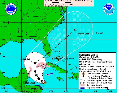
As of 11 pm EDT Tuesday, Hurricane Wilma continued to "rapidly intensify" and the NHC was saying, "Wilma has developed the dreaded pinhole eye."
The hurricane reached Category 2 status late Tuesday evening. It is expected to strengthen further to Category 4 status some time in the next 24 hours "and it would not be a surprise to see it reach Category Five" before it tops out, the Hurricane Center says.
The NHC's now projects the storm is likely to swing a little west of earlier forecasts before being pushed back toward the Northeast:
"The new forecast track is adjusted somewhat to the left for the first 48 hours based on current position and motion... . It should be noted that the models do not completely agree... and these differences could make a significant difference in what parts of Florida Wilma will ultimately affect."Earlier Tuesday evening, Derek Ortt wrote for the Pensacola News Journal:
"The all clear has not been given for Pensacola, especially with the track moving west of the forecast track. Right now, it appears as if high waves will be all that is seen, though residents should continue to closely monitor the progress of this dangerous hurricane in case the track shifts farther west than expected."Locally, no one appears to be making any preparations yet. It's too early and as yet too uncertain that the storm will approach sufficiently close to the Northwest Florida panhandle. In public places, however, casual conversation inevitably touches on Wilma and the possibility, however remote, that the forecast path might -- just might -- change again in the next few days.


No comments:
Post a Comment