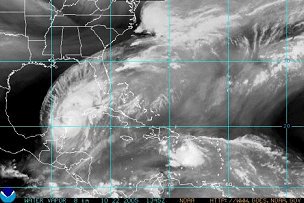
After slamming Cozumel and Isle de Mujeres, Hurricane Wilma is moving at a painfully slow pace over the Yucatan peninsula. This is very bad news for the low, flat, heavily forested limestone shelf that makes up most of the Yucatan.
But it's good news for south Florida. Early Saturday morning the NHC was saying:
It is becoming more and more definite that Hurricane Wilma will cross Florida in a hurry on Monday. The longer that Wilma remains nearly stationary... the chances become greater for a more East-Northeasterly track as indicated by some guidance.There is bad news brewing, however. A tropical wave in the eastern Caribbean "has become more concentrated about 200 miles south of Puerto Rico," the NHC reports. "Conditions appear to be favorable for a tropical depression to form during the next day or so as it moves West-Northwestward... ."
The intensity of Wilma while crossing Florida is highly uncertain and the best estimate is that it will likely be a category one or two at landfall. Wilma's wind field will probably expand as it crosses the Florida peninsula. Therefore... the tropical storm force winds will likely cover a large area.
Based on the track forecast and the large area of tropical storm force winds associated with Wilma... a hurricane watch will likely be issued later today for portions of central and south Florida and the Florida Keys.
As of 8 a.m. EDT, the NHC reported, "This system has become better organized and has the potential to develop into a tropical cyclone within the next 24 to 36 hours."


No comments:
Post a Comment