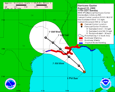
 The early Sunday afternoon NHC advisory remains pretty much the same: Gustav is a Cat 3 but may re-intensify to a Cat-4 within the next 24 hours. The projected path bringing this major hurricane ashore just west of New Orleans remains roughly the same.
Pensacola and the rest of the Florida Panhandle to Tallahassee remain under a Tropical Storm
Rumors to the contrary notwithstanding, Escambia County Emergency Management officials have not -- repeat, not -- ordered any evacuations as yet. However, swimming in the Gulf is now prohibited; and, alas, "the bathtub races scheduled for 2 pm today" have been postponed.
Local conditions: Overcast skies, warm, dry, muggy, with light winds and occasional gusts to 15 mph.
UPDATE I
3 pm
Sudden pick-up in wind, now stiff and gusting to 35 mph. Bands of driving rain have arrived. Typically for a tropical storm, the rain is cold, almost horizontal, and comes in needle-like drops.
6:30 pm
No more rain bands, as of now, since mid-afternoon, but meteorologist Derek Ortt over at the PNJ's Storm Watch blog says:
The main rain shield is not too far from the coastline. This may move onshore during the evening hours. If this does move over the area, sustained tropical storm force winds with higher gusts will begin to affect the area.
UPDATE III
7:00 pm
7:00 pm
"You Can't Probably Shouldn't Go Home Again"
Mercenaries are being recruited by Blackwater Worldwide "to potentially deploy to provide security in the possible aftermath of Hurricane Gustav. This is the first time Blackwater has mobilized under its controversial Homeland Security contracts."


1 comment:
Actually, it's a Tropical Storm Warning now, no longer a Watch. Just so we're all aware.
Post a Comment